
Westland District topographic map
Interactive map
Click on the map to display elevation.
About this map
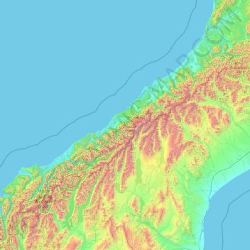
Name: Westland District topographic map, elevation, terrain.
Location: Westland District, West Coast, New Zealand (-44.49907 168.05287 -42.56006 171.88439)
Average elevation: 1,434 ft
Minimum elevation: -3 ft
Maximum elevation: 11,342 ft
Other topographic maps
Click on a map to view its topography, its elevation and its terrain.
Punakaiki
New Zealand > West Coast > Buller District
Punakaiki, Buller District, West Coast, 7873, New Zealand
Average elevation: 230 ft
Douglas Pass
New Zealand > West Coast > Westland District
Douglas Pass, Westland District, West Coast, New Zealand
Average elevation: 5,259 ft
Lake Windermere
New Zealand > West Coast > Westland District
Lake Windermere, Westland District, West Coast, New Zealand
Average elevation: 13 ft
Katau Knob
New Zealand > West Coast > Westland District
Katau Knob, Westland District, West Coast, New Zealand
Average elevation: 2,710 ft
Pike Peak
New Zealand > West Coast > Buller District
Pike Peak, Buller District, West Coast, New Zealand
Average elevation: 3,622 ft
Snowden
New Zealand > West Coast > Westland District
Snowden, Westland District, West Coast, New Zealand
Average elevation: 3,442 ft
Mt Wilson
New Zealand > West Coast > Westland District
Mt Wilson, Westland District, West Coast, New Zealand
Average elevation: 3,694 ft
Ōkārito
New Zealand > West Coast > Westland District
Ōkārito, Westland District, West Coast, New Zealand
Average elevation: 82 ft
Mount Baldy
New Zealand > West Coast > Buller District
Mount Baldy, Buller District, West Coast, New Zealand
Average elevation: 3,474 ft
Whataroa River
New Zealand > West Coast > Westland District
Whataroa River, Westland District, West Coast, New Zealand
Average elevation: 2,054 ft