Geolocate

Dayton topographic map

Click on the map to display elevation.

About this map

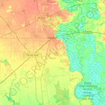
Name: Dayton topographic map, elevation, terrain.

Location: Dayton, Liberty County, Texas, 77535, United States (29.89749 -95.00843 30.13085 -94.85380)

Average elevation: 52 ft

Minimum elevation: 0 ft

Maximum elevation: 105 ft

Liberty County trails, hiking, mountain biking, running and outdoor activities

Other topographic maps

Click on a map to view its topography, its elevation and its terrain.

Colony Ridge

United States > Texas > Liberty County

Average elevation: 112 ft

Hightower

United States > Texas > Liberty County

Average elevation: 161 ft

Rye

United States > Texas > Liberty County

Average elevation: 102 ft

South Dayton

United States > Texas > Liberty County

Average elevation: 59 ft

Romayor

United States > Texas > Liberty County

Average elevation: 75 ft

Cleveland

United States > Texas > Liberty County > Cleveland > Cleveland

Average elevation: 151 ft

Gear up for your next adventure:

💧Water Purification System - Clean water on the trail with reliable purifiers
🛰️Handheld GPS Units - Professional satellite navigators for precise backcountry mapping
👖Convertible Hiking Pants - Versatile zip-off pants for changing altitudes and temperatures
🔦Powerful Headlamps - Ultra-bright hands-free lighting for night navigation
🪶Camp Gear Gift Set - Perfect gift bundle for outdoor fans

As an Amazon Associate, this site earns from qualifying purchases at no extra cost to you.