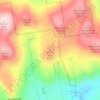
Sanbornton topographic map
Click on the map to display elevation.
Sanbornton
According to the United States Census Bureau, the town has a total area of 49.7 square miles (128.6 km2), of which 47.4 sq mi (122.7 km2) are land and 2.3 sq mi (5.9 km2) are water, comprising 4.58% of the town. Bounded on the west by the Pemigewasset River and on the east by Lake Winnisquam, Sanbornton is largely drained by Salmon Brook, a tributary of the Pemigewasset. The highest point in town is the summit of Hersey Mountain, elevation 2,001 feet (610 m) above sea level, along the town's northwestern border.
About this map
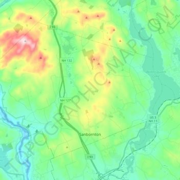
Name: Sanbornton topographic map, elevation, terrain.
Average elevation: 748 ft
Minimum elevation: 295 ft
Maximum elevation: 1,962 ft
Belknap County trails, hiking, mountain biking, running and outdoor activities
Other topographic maps
Click on a map to view its topography, its elevation and its terrain.
Gilmanton Ironworks
United States > New Hampshire > Belknap County > Gilmanton
Average elevation: 735 ft
Governors Island
United States > New Hampshire > Belknap County > Gilford > Dockham Shore
Average elevation: 531 ft
Diamond Island
United States > New Hampshire > Belknap County > Gilford > Coleman Point
Average elevation: 505 ft
Rattlesnake Island
United States > New Hampshire > Belknap County > Alton
Rattlesnake Island is about 2 miles (3 km) long, and approximately 5 miles (8 km) around its shore. The topography varies greatly. Some sections of the island are quite steep, with the land rising steeply from the shore (affording views of the area), while other sections, particularly on the "peninsula", which…
Average elevation: 522 ft
Halfmoon Lake
United States > New Hampshire > Belknap County > Barnstead > Fernhill
Average elevation: 699 ft
Sleepers Island
United States > New Hampshire > Belknap County > Alton > Smith Point
Average elevation: 535 ft
Gunstock Mountain
United States > New Hampshire > Belknap County > Gilford
Average elevation: 1,496 ft