Make a donation
Gear up for your next adventure:
As an Amazon Associate, this site earns from qualifying purchases at no extra cost to you.
Munising topographic map
Click on the map to display elevation.
Make a donation
Gear up for your next adventure:
As an Amazon Associate, this site earns from qualifying purchases at no extra cost to you.
About this map
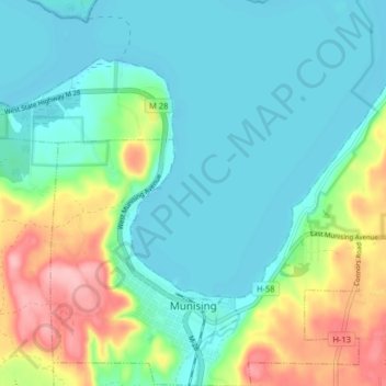
Name: Munising topographic map, elevation, terrain.
Location: Munising, Alger County, Michigan, 49862, United States (46.39838 -86.67921 46.45372 -86.60459)
Average elevation: 699 ft
Minimum elevation: 577 ft
Maximum elevation: 1,024 ft
Alger County trails, hiking, mountain biking, running and outdoor activities
Make a donation
Gear up for your next adventure:
As an Amazon Associate, this site earns from qualifying purchases at no extra cost to you.
Other topographic maps
Click on a map to view its topography, its elevation and its terrain.
Make a donation
Gear up for your next adventure:
As an Amazon Associate, this site earns from qualifying purchases at no extra cost to you.
Christmas
United States > Michigan > Alger County > Au Train Township > Christmas
Average elevation: 666 ft
