Geolocate

Allhallows topographic map

Click on the map to display elevation.

About this map

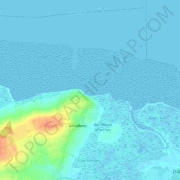
Name: Allhallows topographic map, elevation, terrain.

Location: Allhallows, Medway, England, United Kingdom (51.45348 0.60703 51.50368 0.69480)

Average elevation: 16 ft

Minimum elevation: -7 ft

Maximum elevation: 138 ft

Other topographic maps

Click on a map to view its topography, its elevation and its terrain.

Broad Street

United Kingdom > England > Medway > Hoo St. Werburgh

Average elevation: 82 ft

Upnor Castle

United Kingdom > England > Medway > Upper Upnor

Average elevation: 46 ft

Hillside

United Kingdom > England > Medway > Allhallows

Average elevation: 30 ft

Kingsnorth

United Kingdom > England > Medway

Average elevation: 36 ft

Damhead Creek

United Kingdom > England > Medway > Kingsnorth

Average elevation: 13 ft

Silver Street

United Kingdom > England > Medway > Wainscott

Average elevation: 95 ft

Upper Halling

United Kingdom > England > Medway

Average elevation: 203 ft

Chatham

United Kingdom > England > Medway

Average elevation: 161 ft

Salters Cross

United Kingdom > England > Medway > Strood

Average elevation: 180 ft

Cliffe

United Kingdom > England > Medway

Average elevation: 16 ft

Borstal

United Kingdom > England > Medway > Rochester

Average elevation: 144 ft

Lords Wood

United Kingdom > England > Medway

Average elevation: 440 ft

Haven Street

United Kingdom > England > Medway > Wainscott

Average elevation: 98 ft

Cuxton Brickfield

United Kingdom > England > Medway > Borstal

Average elevation: 144 ft

Beacon Close

United Kingdom > England > Medway > Allhallows

Average elevation: 30 ft

Middle Stoke

United Kingdom > England > Medway > Upper Stoke

Average elevation: 36 ft

Upper Stoke

United Kingdom > England > Medway

Average elevation: 46 ft

Lower Upnor

United Kingdom > England > Medway

Average elevation: 72 ft

Wainscott

United Kingdom > England > Medway

Average elevation: 85 ft

Brompton

United Kingdom > England > Medway > Gillingham

Average elevation: 79 ft

Hale

United Kingdom > England > Medway > Gillingham

Average elevation: 246 ft

The Mount

United Kingdom > England > Medway > Wainscott

Average elevation: 102 ft

Cliffe Woods

United Kingdom > England > Medway

Average elevation: 75 ft

Buckland

United Kingdom > England > Medway

Average elevation: 36 ft

Farthing Corner

United Kingdom > England > Medway > Gillingham

Average elevation: 325 ft

Fort Borstal

United Kingdom > England > Medway > Rochester > Borstal

Average elevation: 164 ft

Lee Green

United Kingdom > England > Medway > Frindsbury

Average elevation: 89 ft

West Street

United Kingdom > England > Medway > Cliffe

Average elevation: 13 ft

Beluncle

United Kingdom > England > Medway > Kingsnorth

Average elevation: 56 ft

Beluncle

United Kingdom > England > Medway > Hoo St. Werburgh

Average elevation: 56 ft

Gear up for your next adventure:

🔌USB Car Charger - Car charger for on‑the‑go power needs
🎁Geography Themed Gifts - Unique gift ideas for map lovers and geography enthusiasts
🔋Rechargeable Batteries - Power up your outdoor devices
🛰️Satellite Messengers - Emergency SOS and two-way messaging for off-grid adventures
🌐World Map Poster - Decorative world maps with topographic info

As an Amazon Associate, this site earns from qualifying purchases at no extra cost to you.