Geolocate

Upper Halling topographic map

Click on the map to display elevation.

About this map

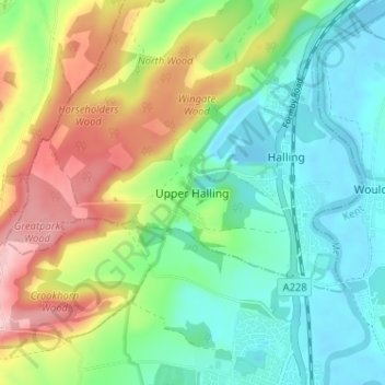
Name: Upper Halling topographic map, elevation, terrain.

Location: Upper Halling, Medway, England, ME2 1JD, United Kingdom (51.33082 0.40841 51.37082 0.44841)

Average elevation: 203 ft

Minimum elevation: -20 ft

Maximum elevation: 594 ft

Other topographic maps

Click on a map to view its topography, its elevation and its terrain.

Gillingham

United Kingdom > England > Medway

Average elevation: 194 ft

Chatham

United Kingdom > England > Medway

Average elevation: 230 ft

Upnor Castle

United Kingdom > England > Medway > Upper Upnor

Average elevation: 46 ft

Hillside

United Kingdom > England > Medway > Allhallows

Average elevation: 30 ft

Isle of Grain

United Kingdom > England > Medway > Grain

Average elevation: 7 ft

Strood

United Kingdom > England > Medway

Average elevation: 89 ft

Damhead Creek

United Kingdom > England > Medway > Kingsnorth

Average elevation: 13 ft

Cuxton

United Kingdom > England > Medway

Average elevation: 187 ft

Hoo St. Werburgh

United Kingdom > England > Medway

Average elevation: 52 ft

Beacon Close

United Kingdom > England > Medway > Allhallows

Average elevation: 30 ft

Allhallows

United Kingdom > England > Medway

Average elevation: 16 ft

Fort Borstal

United Kingdom > England > Medway > Rochester > Borstal

Average elevation: 164 ft

Gillingham

United Kingdom > England > Medway

Average elevation: 194 ft

Isle of Grain

United Kingdom > England > Medway > Grain

Average elevation: 7 ft

Hoo St. Werburgh

United Kingdom > England > Medway

Average elevation: 59 ft

Gear up for your next adventure:

🦶Hiking Gaiters - Keep debris and water out of your boots
🎒Trail Energy Bars - High‑calorie bars for hiking energy
🪶Paracord Bracelet - Survival bracelet with built‑in tools
🔌USB Car Charger - Car charger for on‑the‑go power needs
🪶Compact Camp Shovel - Folding shovel for campsite tasks

As an Amazon Associate, this site earns from qualifying purchases at no extra cost to you.