Geolocate
👉 Easily get elevation data in JSON, GeoTIFF and KML formats using Elevation API
Thank you for supporting this site ❤️
Make a donation

St. Helena topographic map

Click on the map to display elevation.

About this map

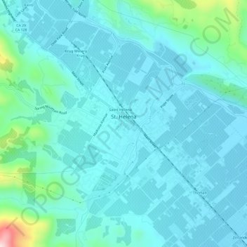
Name: St. Helena topographic map, elevation, terrain.

Location: St. Helena, Napa County, California, 94574, United States (38.48480 -122.49504 38.52306 -122.43621)

Average elevation: 364 ft

Minimum elevation: 187 ft

Maximum elevation: 1,490 ft

Napa County trails, hiking, mountain biking, running and outdoor activities

Other topographic maps

Click on a map to view its topography, its elevation and its terrain.

Lake Berryessa

United States > California > Napa County

Average elevation: 1,056 ft

Thompson

United States > California > Napa County > Thompson

Average elevation: 43 ft

Howell Mountain

United States > California > Napa County

Average elevation: 1,745 ft

Napa Abajo

United States > California > Napa County > Napa

Average elevation: 62 ft

Oakville

United States > California > Napa County

Average elevation: 200 ft

Pope Valley

United States > California > Napa County

Average elevation: 935 ft

Sanitarium

United States > California > Napa County

Average elevation: 702 ft

Krug

United States > California > Napa County > St. Helena

Average elevation: 410 ft

Gear up for your next adventure:

🏔️Mountain Trail Maps - High‑detail maps for popular peaks
🛰️Handheld GPS Units - Professional satellite navigators for precise backcountry mapping
🖼️Topo Map Wall Art - Decorative topographic prints of famous peaks and regions
🌡️Handheld Weather Meters - Measure wind, temp, and pressure for safe mountain travel
⛑️Personal Locator Beacon - Safety beacon for emergencies

As an Amazon Associate, this site earns from qualifying purchases at no extra cost to you.