
Dover topographic map
Click on the map to display elevation.
About this map
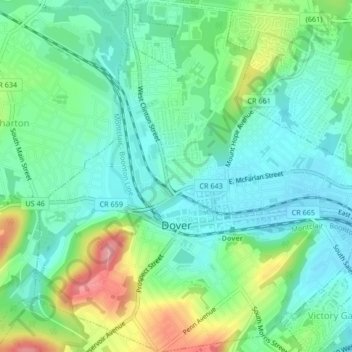
Name: Dover topographic map, elevation, terrain.
Location: Dover, Morris County, New Jersey, 07801, United States (40.87262 -74.57896 40.90411 -74.53811)
Average elevation: 673 ft
Minimum elevation: 554 ft
Maximum elevation: 948 ft
Morris County trails, hiking, mountain biking, running and outdoor activities
Other topographic maps
Click on a map to view its topography, its elevation and its terrain.
Kenvil
United States > New Jersey > Morris County > Roxbury Township > Succasunna
Average elevation: 784 ft
Washington Valley
United States > New Jersey > Morris County > Morris Township
Average elevation: 499 ft
Powder Mill Pond Dam
United States > New Jersey > Morris County > Parsippany-Troy Hills > Tabor
Average elevation: 584 ft
Parsippany
United States > New Jersey > Morris County > Parsippany-Troy Hills
Average elevation: 312 ft
Mooney Mountain Park
United States > New Jersey > Morris County > Roxbury Township
Average elevation: 1,070 ft
Lake Parsippany
United States > New Jersey > Morris County > Parsippany-Troy Hills
Average elevation: 305 ft
Schooleys Mountain
United States > New Jersey > Morris County > Washington Township
Average elevation: 961 ft
Mount Freedom
United States > New Jersey > Morris County > Randolph Township
Average elevation: 883 ft
Pleasant Valley
United States > New Jersey > Morris County > Mendham Township
Average elevation: 512 ft
Calais Crossroads
United States > New Jersey > Morris County > Randolph Township
Average elevation: 932 ft
Lower Montville
United States > New Jersey > Morris County > Montville Township
Average elevation: 276 ft
Parsippany
United States > New Jersey > Morris County > Parsippany-Troy Hills
Average elevation: 312 ft
Washington Corner
United States > New Jersey > Morris County > Mendham Township
Average elevation: 571 ft
Lake Hiawatha
United States > New Jersey > Morris County > Parsippany-Troy Hills
Average elevation: 249 ft
Rockaway Valley
United States > New Jersey > Morris County > Boonton Township
Average elevation: 594 ft
Roxbury Township
United States > New Jersey > Morris County > Roxbury Township
Average elevation: 866 ft
Floral Hill
United States > New Jersey > Morris County > Chatham Township > Floral Hill
Average elevation: 295 ft