Geolocate

Athens topographic map

Click on the map to display elevation.

About this map

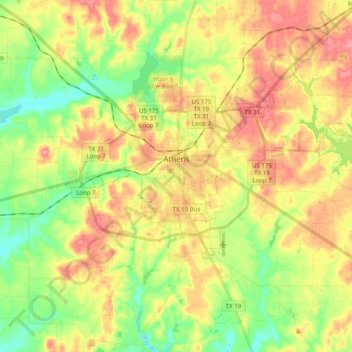
Name: Athens topographic map, elevation, terrain.

Location: Athens, Henderson County, Texas, 75751, United States (32.15688 -95.91720 32.23531 -95.71901)

Average elevation: 459 ft

Minimum elevation: 322 ft

Maximum elevation: 600 ft

Henderson County trails, hiking, mountain biking, running and outdoor activities

Other topographic maps

Click on a map to view its topography, its elevation and its terrain.

Trinity River

United States > Texas > Henderson County > Tool

Average elevation: 302 ft

Lake Palestine

United States > Texas > Henderson County > Chandler

Average elevation: 367 ft

Murchison

United States > Texas > Henderson County

Average elevation: 479 ft

Gear up for your next adventure:

🌡️Handheld Weather Meters - Measure wind, temp, and pressure for safe mountain travel
🦺Reflective Outdoor Gear - Safety gear for low‑light conditions
Camping Coffee Makers - Enjoy premium coffee at the summit or campsite
👖Convertible Hiking Pants - Versatile zip-off pants for changing altitudes and temperatures
🥇GPS Hiking Watch - Multi‑sport GPS watch with navigation and trail tracking

As an Amazon Associate, this site earns from qualifying purchases at no extra cost to you.