Geolocate

Nairobi Dam topographic map

Click on the map to display elevation.

About this map

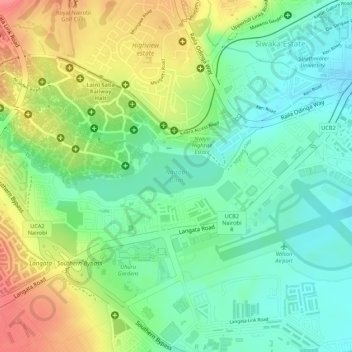
Name: Nairobi Dam topographic map, elevation, terrain.

Location: Nairobi Dam, Siwaka Estate, Nairobi, Nairobi County, Kenya (-1.32067 36.79515 -1.31681 36.80669)

Average elevation: 5,561 ft

Minimum elevation: 5,446 ft

Maximum elevation: 5,722 ft

Other topographic maps

Click on a map to view its topography, its elevation and its terrain.

Roysambu ward

Kenya > Nairobi County > Nairobi

Average elevation: 5,361 ft

Ruaraka

Kenya > Nairobi County > Nairobi

Average elevation: 5,302 ft

Kagondo

Kenya > Nairobi County > Nairobi

Average elevation: 6,224 ft

Gear up for your next adventure:

🧺Microfiber Travel Towels - Compact and fast-drying towels for trail use
🌡️Handheld Weather Meters - Measure wind, temp, and pressure for safe mountain travel
📷Action Cameras - Rugged cameras to document your journeys across rugged terrain
🔊Portable Camp Speaker - Music and alerts at camp
🦶Carbon Trekking Poles - Reduce knee impact on steep descents with ultra-light poles

As an Amazon Associate, this site earns from qualifying purchases at no extra cost to you.