Geolocate

Carvalhas topographic map

Click on the map to display elevation.

About this map

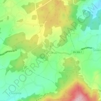
Name: Carvalhas topographic map, elevation, terrain.

Location: Carvalhas, Barcelos, Braga, Portugal (41.45660 -8.61088 41.48668 -8.58365)

Average elevation: 495 ft

Minimum elevation: 180 ft

Maximum elevation: 984 ft

Other topographic maps

Click on a map to view its topography, its elevation and its terrain.

Vila Cova

Portugal > Braga > Barcelos

Average elevation: 322 ft

Franqueira

Portugal > Braga > Barcelos

Average elevation: 479 ft

Silveiros

Portugal > Braga > Barcelos

Average elevation: 446 ft

Fonte Coberta

Portugal > Braga > Barcelos

Average elevation: 384 ft

Monte do Facho

Portugal > Braga > Barcelos > Roriz

Average elevation: 397 ft

Feitos

Portugal > Braga > Barcelos

Average elevation: 850 ft

Milhazes

Portugal > Braga > Barcelos

Average elevation: 272 ft

Vilar do Monte

Portugal > Braga > Barcelos

Average elevation: 541 ft

Gonçalo

Portugal > Braga > Barcelos

Average elevation: 1,138 ft

Martim de Além

Portugal > Braga > Barcelos > Martim

Average elevation: 440 ft

Durrães

Portugal > Braga > Barcelos

Average elevation: 433 ft

Gear up for your next adventure:

🧭Map Reading Tools - Tools and kits for map navigation
🥾Hiking Shoes - Durable and comfortable shoes for trail hiking
📷Action Cameras - Rugged cameras to document your journeys across rugged terrain
🔭Telescopic Hiking Pole - Adjustable pole for hiking stability
🔌USB Car Charger - Car charger for on‑the‑go power needs

As an Amazon Associate, this site earns from qualifying purchases at no extra cost to you.