
Make a donation
Gear up for your next adventure:
As an Amazon Associate, this site earns from qualifying purchases at no extra cost to you.
Nesquehoning topographic map
Click on the map to display elevation.
Make a donation
Gear up for your next adventure:
As an Amazon Associate, this site earns from qualifying purchases at no extra cost to you.
Nesquehoning
Nesquehoning is located at 40°52′5″N 75°49′27″W / 40.86806°N 75.82417°W / 40.86806; -75.82417 (40.868178, -75.824176). According to the U.S. Census Bureau, the borough has a total area of 21.6 square miles (56 km2), of which, 21.2 square miles (55 km2) is land and 0.4 square miles (1.0 km2) (1.90%) is water. Nesquehoning is 3 miles (4.8 km) west of Jim Thorpe and 4 miles (6.4 km) northeast of Lansford. Nesquehoning's elevation is 830 feet (250 m) above sea level. It has a warm-summer humid continental climate (Dfb) and its monthly average temperatures range from 26.5 °F (−3.1 °C) in January to 71.1 °F (21.7 °C) in July. The hardiness zone is 6a.
Make a donation
Gear up for your next adventure:
As an Amazon Associate, this site earns from qualifying purchases at no extra cost to you.
About this map
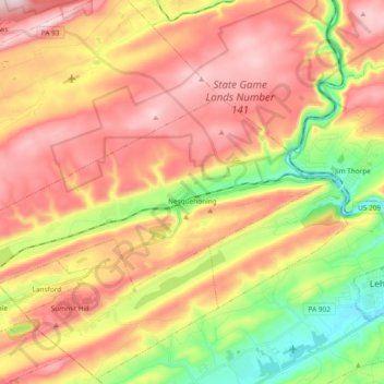
Name: Nesquehoning topographic map, elevation, terrain.
Average elevation: 1,207 ft
Minimum elevation: 466 ft
Maximum elevation: 1,867 ft
Carbon County trails, hiking, mountain biking, running and outdoor activities
Make a donation
Gear up for your next adventure:
As an Amazon Associate, this site earns from qualifying purchases at no extra cost to you.
Other topographic maps
Click on a map to view its topography, its elevation and its terrain.
Leonardsville
United States > Pennsylvania > Carbon County > Kidder Township
Average elevation: 1,660 ft
Lake Harmony
United States > Pennsylvania > Carbon County > Kidder Township
Average elevation: 1,808 ft
Beltzville Lake
United States > Pennsylvania > Carbon County > Towamensing Township
Average elevation: 886 ft
Make a donation
Gear up for your next adventure:
As an Amazon Associate, this site earns from qualifying purchases at no extra cost to you.
Pleasant Corners
United States > Pennsylvania > Carbon County > Mahoning Township
Average elevation: 732 ft
Christian Corner
United States > Pennsylvania > Carbon County > Lower Towamensing Township
Average elevation: 741 ft
Make a donation
Gear up for your next adventure:
As an Amazon Associate, this site earns from qualifying purchases at no extra cost to you.
Pisgah Mountain
United States > Pennsylvania > Carbon County > Summit Hill
Average elevation: 1,322 ft
White Bear Creek
United States > Pennsylvania > Carbon County > Summit Hill
Average elevation: 1,332 ft
East Jim Thorpe
United States > Pennsylvania > Carbon County > Jim Thorpe > East Jim Thorpe
Average elevation: 892 ft