
Make a donation
Gear up for your next adventure:
As an Amazon Associate, this site earns from qualifying purchases at no extra cost to you.
The Vly topographic map
Click on the map to display elevation.
Make a donation
Gear up for your next adventure:
As an Amazon Associate, this site earns from qualifying purchases at no extra cost to you.
About this map
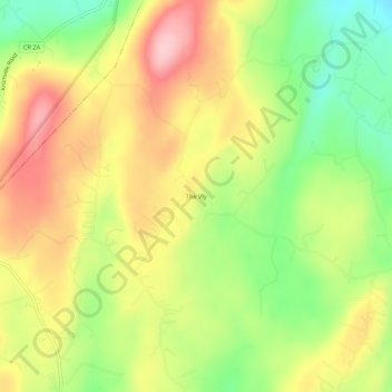
Name: The Vly topographic map, elevation, terrain.
Average elevation: 833 ft
Minimum elevation: 525 ft
Maximum elevation: 1,135 ft
Ulster County trails, hiking, mountain biking, running and outdoor activities
Make a donation
Gear up for your next adventure:
As an Amazon Associate, this site earns from qualifying purchases at no extra cost to you.
Other topographic maps
Click on a map to view its topography, its elevation and its terrain.
Town of Shandaken
United States > New York > Ulster County
The town is inside the Catskill Park, and is entirely mountainous. Within it lies Slide Mountain, the Catskill Mountains' highest peak at 4,180 ft (1,270 m), and several of the other Catskill High Peaks over 3,500 ft (1,100 m) in elevation.
Average elevation: 2,139 ft
Village of New Paltz
United States > New York > Ulster County > Town of New Paltz
Average elevation: 276 ft
Saugerties South
United States > New York > Ulster County > Town of Saugerties
Average elevation: 108 ft
Make a donation
Gear up for your next adventure:
As an Amazon Associate, this site earns from qualifying purchases at no extra cost to you.
Sojourner Truth State Park
United States > New York > Ulster County > City of Kingston > East Kingston
Average elevation: 125 ft
Make a donation
Gear up for your next adventure:
As an Amazon Associate, this site earns from qualifying purchases at no extra cost to you.
Make a donation
Gear up for your next adventure:
As an Amazon Associate, this site earns from qualifying purchases at no extra cost to you.
Slide Mountain Wilderness
United States > New York > Ulster County > Town of Shandaken > Town of Denning
Within its boundaries lie 10 of the 35 Catskill High Peaks, including the highest Catskill peak, Slide, 4,180 feet (1277 m) of elevation; and lowest, Rocky.
Average elevation: 1,916 ft
Make a donation
Gear up for your next adventure:
As an Amazon Associate, this site earns from qualifying purchases at no extra cost to you.
Big Indian Park
United States > New York > Ulster County > Town of Shandaken > Big Indian
Average elevation: 1,617 ft
Glenbrook Park
United States > New York > Ulster County > Town of Shandaken
Average elevation: 1,499 ft
Make a donation
Gear up for your next adventure:
As an Amazon Associate, this site earns from qualifying purchases at no extra cost to you.
Mohonk Mountain House Property
United States > New York > Ulster County > Town of New Paltz
Average elevation: 748 ft
Bear Hill Preserve (Cragsmoor Free Library)
United States > New York > Ulster County > Town of Wawarsing > Cragsmoor
Average elevation: 1,358 ft