
Town of Gardiner topographic map
Interactive map
Click on the map to display elevation.
About this map
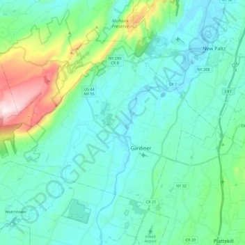
Name: Town of Gardiner topographic map, elevation, terrain.
Average elevation: 512 ft
Minimum elevation: 171 ft
Maximum elevation: 2,110 ft
Other topographic maps
Click on a map to view its topography, its elevation and its terrain.
Big Indian
United States > New York > Ulster County > Town of Shandaken
Big Indian, Town of Shandaken, Ulster County, New York, 12410, United States
Average elevation: 1,762 ft
Gardiner
United States > New York > Ulster County > Gardiner
Gardiner, Ulster County, New York, United States
Average elevation: 331 ft
Glasco
United States > New York > Ulster County > Town of Saugerties
Glasco, Town of Saugerties, Ulster County, New York, 12432, United States
Average elevation: 98 ft
City of Kingston
United States > New York > Ulster County
City of Kingston, Ulster County, New York, 12401, United States
Average elevation: 171 ft
Sam's Point Overlook
United States > New York > Ulster County > Town of Wawarsing > Village of Ellenville
Sam's Point Overlook, Loop Road, Village of Ellenville, Town of Wawarsing, Ulster County, New York, 12420, United States
Average elevation: 1,778 ft
Town of Esopus
United States > New York > Ulster County
Town of Esopus, Ulster County, New York, United States
Average elevation: 259 ft
Bear Hill Preserve (Cragsmoor Free Library)
United States > New York > Ulster County > Town of Wawarsing > Cragsmoor
Bear Hill Preserve (Cragsmoor Free Library), Route 52, Cragsmoor, Town of Wawarsing, Town of Shawangunk, Ulster County, New York, 12428, United States
Average elevation: 1,358 ft
Rondout
United States > New York > Ulster County > City of Kingston
Rondout, City of Kingston, Ulster County, New York, 12417, United States
Average elevation: 115 ft
New Paltz
United States > New York > Ulster County > New Paltz
New Paltz, Town of New Paltz, Ulster County, New York, 12561, United States
Average elevation: 279 ft
Mohonk Mountain House Property
United States > New York > Ulster County > Town of Marbletown
Mohonk Mountain House Property, Town of Marbletown, Town of Rochester, Ulster County, New York, United States
Average elevation: 748 ft
Connelly
United States > New York > Ulster County > Town of Esopus > Port Ewen
Connelly, Port Ewen, Town of Esopus, Ulster County, New York, 12417, United States
Average elevation: 144 ft
Sholam
United States > New York > Ulster County > Town of Wawarsing
Sholam, Town of Wawarsing, Ulster County, New York, 12458, United States
Average elevation: 1,257 ft
Napanoch
United States > New York > Ulster County > Town of Wawarsing
Napanoch, Town of Wawarsing, Ulster County, New York, United States
Average elevation: 479 ft
Mount Marion Park
United States > New York > Ulster County > Town of Saugerties
Mount Marion Park, Town of Saugerties, Ulster County, New York, 12477, United States
Average elevation: 246 ft
Saugerties South
United States > New York > Ulster County > Town of Saugerties
Saugerties South, Town of Saugerties, Ulster County, New York, United States
Average elevation: 108 ft
Stone Ridge
United States > New York > Ulster County > Town of Marbletown
Stone Ridge, Town of Marbletown, Ulster County, New York, United States
Average elevation: 305 ft
Milton
United States > New York > Ulster County
Milton, Town of Marlborough, Ulster County, New York, 12547, United States
Average elevation: 253 ft
Village of Saugerties
United States > New York > Ulster County
Village of Saugerties, Town of Saugerties, Ulster County, New York, United States
Average elevation: 112 ft
Big Indian Park
United States > New York > Ulster County > Town of Shandaken > Big Indian
Big Indian Park, Big Indian, Town of Shandaken, Ulster County, New York, United States
Average elevation: 1,617 ft
Glenbrook Park
United States > New York > Ulster County > Town of Shandaken
Glenbrook Park, Town of Shandaken, Ulster County, New York, 12480, United States
Average elevation: 1,499 ft
Woodstock
United States > New York > Ulster County > Woodstock
Woodstock, Town of Woodstock, Ulster County, New York, 12498, United States
Average elevation: 814 ft
Bruceville
United States > New York > Ulster County > Town of Rosendale
Bruceville, High Falls, Town of Rosendale, Ulster County, New York, 12440, United States
Average elevation: 276 ft
Saint Remy
United States > New York > Ulster County > Town of Esopus
Saint Remy, Town of Esopus, Ulster County, New York, 12411, United States
Average elevation: 230 ft
Town of Wawarsing
United States > New York > Ulster County
Town of Wawarsing, Ulster County, New York, United States
Average elevation: 1,004 ft
Winchell
United States > New York > Ulster County
Winchell, Town of Olive, Ulster County, New York, 12461, United States
Average elevation: 1,027 ft
Lone Mountain
United States > New York > Ulster County > Town of Denning
Lone Mountain, Town of Denning, Ulster County, New York, United States
Average elevation: 3,002 ft
Cherrytown
United States > New York > Ulster County
Cherrytown, Town of Rochester, Ulster County, New York, 12446, United States
Average elevation: 899 ft
Clintondale
United States > New York > Ulster County > Town of Plattekill
Clintondale, Town of Plattekill, Ulster County, New York, United States
Average elevation: 568 ft
Highland Landing
United States > New York > Ulster County > Highland
Highland Landing, Highland, Town of Lloyd, Ulster County, New York, 12601, United States
Average elevation: 184 ft
Town of Denning
United States > New York > Ulster County
Town of Denning, Ulster County, New York, United States
Average elevation: 2,175 ft
Slide Mountain
United States > New York > Ulster County > Town of Shandaken
Slide Mountain, Town of Shandaken, Ulster County, New York, United States
Average elevation: 3,264 ft
Town of Woodstock
United States > New York > Ulster County
Town of Woodstock, Ulster County, New York, United States
Average elevation: 1,089 ft
Jockey Hill
United States > New York > Ulster County
Jockey Hill, Town of Kingston, Ulster County, New York, United States
Average elevation: 449 ft
The Vly
United States > New York > Ulster County > Town of Marbletown
The Vly, Town of Marbletown, Ulster County, New York, 12484, United States
Average elevation: 833 ft
Slide Mountain Wilderness
United States > New York > Ulster County > Town of Shandaken > Town of Denning
Slide Mountain Wilderness, Town of Denning, Town of Shandaken, Town of Olive, Ulster County, New York, 12464, United States
Average elevation: 1,916 ft
Town of Lloyd
United States > New York > Ulster County
Town of Lloyd, Ulster County, New York, United States
Average elevation: 377 ft
Tabasco
United States > New York > Ulster County
Tabasco, Town of Rochester, Ulster County, New York, 12446, United States
Average elevation: 899 ft
Village of Ellenville
United States > New York > Ulster County > Town of Wawarsing
Village of Ellenville, Town of Wawarsing, Ulster County, New York, United States
Average elevation: 1,066 ft
Town of Plattekill
United States > New York > Ulster County
Town of Plattekill, Ulster County, New York, United States
Average elevation: 531 ft
Hurley
United States > New York > Ulster County
Hurley, Town of Hurley, Ulster County, New York, United States
Average elevation: 262 ft
Town of Saugerties
United States > New York > Ulster County
Town of Saugerties, Ulster County, New York, United States
Average elevation: 302 ft
Town of New Paltz
United States > New York > Ulster County
Town of New Paltz, Ulster County, New York, 12561, United States
Average elevation: 404 ft
Greenfield Park
United States > New York > Ulster County > Town of Wawarsing
Greenfield Park, Town of Wawarsing, Ulster County, New York, 12435, United States
Average elevation: 1,086 ft
Wallkill
United States > New York > Ulster County
Wallkill, Town of Shawangunk, Ulster County, New York, United States
Average elevation: 315 ft
West Shokan
United States > New York > Ulster County
West Shokan, Town of Olive, Ulster County, New York, 12494, United States
Average elevation: 971 ft
Modena
United States > New York > Ulster County > Town of Plattekill
Modena, Town of Plattekill, Ulster County, New York, 12548, United States
Average elevation: 472 ft
Wawarsing
United States > New York > Ulster County > Wawarsing
Wawarsing, Town of Wawarsing, Ulster County, New York, 12489, United States
Average elevation: 748 ft
Minnewaska State Park Preserve
United States > New York > Ulster County > Ellenville
Minnewaska State Park Preserve, Ellenville, Town of Shawangunk, Ulster County, New York, United States
Average elevation: 915 ft
Frost Valley
United States > New York > Ulster County > Town of Denning > Frost Valley
Frost Valley, Town of Denning, Ulster County, New York, United States
Average elevation: 2,411 ft
Rosendale
United States > New York > Ulster County > Rosendale
Rosendale, Town of Rosendale, Ulster County, New York, 12472, United States
Average elevation: 217 ft