
Colfax topographic map
Click on the map to display elevation.
Colfax
Colfax is located in southeastern Washington at 46°53′3″N 117°21′49″W / 46.88417°N 117.36361°W / 46.88417; -117.36361 (46.884033, -117.363668), at an elevation of 1,962 feet (598 m). The nearest cities are Spokane, Pullman, Moscow, and Lewiston/Clarkston. The area is geologically interesting, lying in the midst of the fertile Palouse country in the middle of the Columbia River Plateau, with the Rocky Mountains to the east, the Channeled Scablands to the west, and the Snake River to the south.
About this map
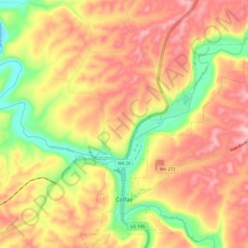
Name: Colfax topographic map, elevation, terrain.
Location: Colfax, Whitman County, Washington, United States (46.86728 -117.38313 46.93245 -117.29317)
Average elevation: 2,247 ft
Minimum elevation: 1,873 ft
Maximum elevation: 2,539 ft
Whitman County trails, hiking, mountain biking, running and outdoor activities
Other topographic maps
Click on a map to view its topography, its elevation and its terrain.
Oaksdale City Park
United States > Washington > Whitman County > Oakesdale
Average elevation: 2,523 ft
Colfax
United States > Washington > Whitman County > Colfax > Colfax
Colfax is located in southeastern Washington at 46°53′3″N 117°21′49″W / 46.88417°N 117.36361°W / 46.88417; -117.36361 (46.884033, -117.363668), at an elevation of 1,962 feet (598 m). The nearest cities are Spokane, Pullman, Moscow, and Lewiston/Clarkston. The area is geologically…
Average elevation: 2,260 ft
LaCrosse
United States > Washington > Whitman County > La Crosse > LaCrosse
Average elevation: 1,545 ft