
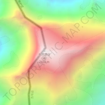
央然康日峰 topographic map
Interactive map
Click on the map to display elevation.
About this map
Name: 央然康日峰 topographic map, elevation, terrain.
Location: 央然康日峰, 吉隆县, 日喀则市, 西藏自治区, 中国 (28.39121 85.12942 28.39131 85.12952)
Average elevation: 21,276 ft
Minimum elevation: 18,189 ft
Maximum elevation: 24,255 ft
央然康日峰(尼泊爾語:याङ्ग्रा हिमाल),位於中國和尼泊爾的邊界,處於馬納斯盧峰東南面,屬於喜馬拉雅山脈的一部分,海拔高度7,422米,法國和瑞士探險隊在1955年10月24日首次登頂。
Other topographic maps
Click on a map to view its topography, its elevation and its terrain.