Geolocate

Lake Austin topographic map

Click on the map to display elevation.

About this map

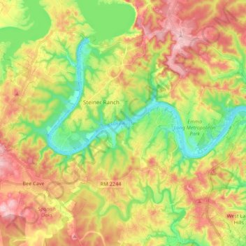
Name: Lake Austin topographic map, elevation, terrain.

Location: Lake Austin, Austin, Travis County, Texas, United States (30.29401 -97.93560 30.39297 -97.77021)

Average elevation: 794 ft

Minimum elevation: 486 ft

Maximum elevation: 1,129 ft

Travis County trails, hiking, mountain biking, running and outdoor activities

Other topographic maps

Click on a map to view its topography, its elevation and its terrain.

Hill of Life Falls

United States > Texas > Travis County > Austin

Average elevation: 764 ft

Mount Bonnell

United States > Texas > Travis County > Austin

Average elevation: 620 ft

Shoal Creek

United States > Texas > Travis County > Austin

Average elevation: 781 ft

Colorado River

United States > Texas > Travis County > Austin

Average elevation: 689 ft

Walnut Creek

United States > Texas > Travis County > Austin

Average elevation: 640 ft

Walter E Long Lake

United States > Texas > Travis County > Austin

Average elevation: 577 ft

Boggy Creek

United States > Texas > Travis County > Austin

Average elevation: 568 ft

Zilker Park

United States > Texas > Travis County > Austin

Average elevation: 512 ft

Cat Mountain

United States > Texas > Travis County > Austin

Average elevation: 679 ft

Mount Barker

United States > Texas > Travis County > Austin

Average elevation: 633 ft

Gear up for your next adventure:

Solar GPS Watches - Advanced multisport watches with built-in topographic maps
👟Men's Trail Runners - Lightweight footwear for fast-paced exploration and light hiking
🧥Men's Rain Shells - Premium waterproof and breathable jackets for mountain weather
🕶️Glacier Sunglasses - Side shields to protect eyes from high-altitude snow glare
🛡️Insect Repellent - Protection against bugs during outdoor activities

As an Amazon Associate, this site earns from qualifying purchases at no extra cost to you.