Geolocate

Washburn topographic map

Click on the map to display elevation.

About this map

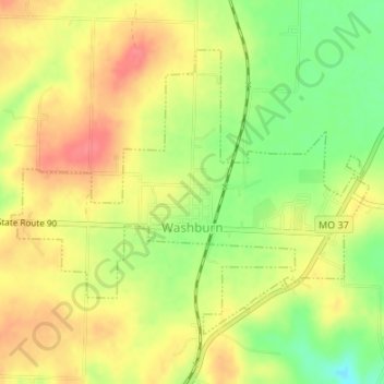
Name: Washburn topographic map, elevation, terrain.

Location: Washburn, Barry County, Missouri, United States (36.57944 -93.98192 36.59947 -93.95050)

Average elevation: 1,496 ft

Minimum elevation: 1,371 ft

Maximum elevation: 1,591 ft

Barry County trails, hiking, mountain biking, running and outdoor activities

Other topographic maps

Click on a map to view its topography, its elevation and its terrain.

Pioneer

United States > Missouri > Barry County

Average elevation: 1,263 ft

Golden

United States > Missouri > Barry County

Average elevation: 1,070 ft

Ridgley

United States > Missouri > Barry County

Average elevation: 1,417 ft

Corsicana

United States > Missouri > Barry County

Average elevation: 1,365 ft

Jenkins

United States > Missouri > Barry County

Average elevation: 1,178 ft

Madry

United States > Missouri > Barry County

Average elevation: 1,509 ft

Cato

United States > Missouri > Barry County

Average elevation: 1,152 ft

Reed Mountain

United States > Missouri > Barry County

Average elevation: 1,447 ft

Gear up for your next adventure:

🔋Rechargeable Batteries - Power up your outdoor devices
🥾Hiking Shoes - Durable and comfortable shoes for trail hiking
🧥Men's Rain Shells - Premium waterproof and breathable jackets for mountain weather
Camping Coffee Makers - Enjoy premium coffee at the summit or campsite
🔦LED Headlamp - Bright and durable LED headlamp for night navigation

As an Amazon Associate, this site earns from qualifying purchases at no extra cost to you.