
Golden topographic map
Click on the map to display elevation.
About this map
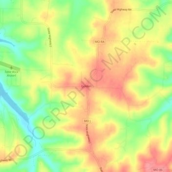
Name: Golden topographic map, elevation, terrain.
Location: Golden, Barry County, Missouri, 65658, United States (36.50459 -93.67401 36.54459 -93.63401)
Average elevation: 1,070 ft
Minimum elevation: 919 ft
Maximum elevation: 1,191 ft
Barry County trails, hiking, mountain biking, running and outdoor activities
Other topographic maps
Click on a map to view its topography, its elevation and its terrain.
Seligman
United States > Missouri > Barry County
Seligman is located in the Ozarks and is, bordered by the Mark Twain National Forest to the east. The town is located on a ridge along Missouri Route 37. Rainfall west of the railroad flows into the Grand Lake o' the Cherokees by way of Big Sugar Creek and Cowskin River. Rainfall to the east of Seligman flows…
Average elevation: 1,532 ft