
Make a donation
Gear up for your next adventure:
As an Amazon Associate, this site earns from qualifying purchases at no extra cost to you.
Reed Mountain topographic map
Click on the map to display elevation.
Make a donation
Gear up for your next adventure:
As an Amazon Associate, this site earns from qualifying purchases at no extra cost to you.
About this map
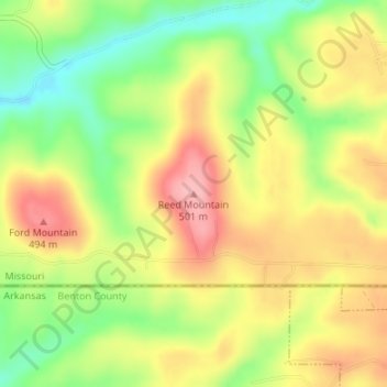
Name: Reed Mountain topographic map, elevation, terrain.
Location: Reed Mountain, Barry County, Missouri, 65745, United States (36.50530 -93.98442 36.50540 -93.98432)
Average elevation: 1,447 ft
Minimum elevation: 1,227 ft
Maximum elevation: 1,654 ft
Barry County trails, hiking, mountain biking, running and outdoor activities
Make a donation
Gear up for your next adventure:
As an Amazon Associate, this site earns from qualifying purchases at no extra cost to you.
Other topographic maps
Click on a map to view its topography, its elevation and its terrain.
Seligman
United States > Missouri > Barry County
Seligman is located in the Ozarks and is, bordered by the Mark Twain National Forest to the east. The town is located on a ridge along Missouri Route 37. Rainfall west of the railroad flows into the Grand Lake o' the Cherokees by way of Big Sugar Creek and Cowskin River. Rainfall to the east of Seligman flows…
Average elevation: 1,532 ft
Make a donation
Gear up for your next adventure:
As an Amazon Associate, this site earns from qualifying purchases at no extra cost to you.