
Shrewsbury topographic map
Interactive map
Click on the map to display elevation.
About this map
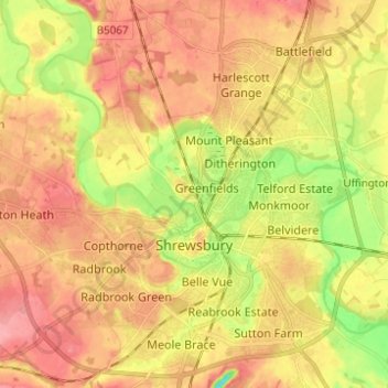
Name: Shrewsbury topographic map, elevation, terrain.
Location: Shrewsbury, Shropshire, England, United Kingdom (52.68019 -2.81432 52.75498 -2.70122)
Average elevation: 226 ft
Minimum elevation: 62 ft
Maximum elevation: 338 ft
Shrewsbury is about 14 miles (23 km) west of Telford, 43 miles (69 km) west of Birmingham and the West Midlands Conurbation, and about 153 miles (246 km) north-west of the capital, London. More locally, the town is to the east of Welshpool, with Bridgnorth and Kidderminster to the south-east. The border with Wales is 9 miles (14 km) to the west. The town centre is partially built on a hill whose elevation is, at its highest, 246 feet (75 m) above sea level. The longest river in the UK, the River Severn, flows through the town, forming a meander around its centre. The town is subject to flooding from the river.
Other topographic maps
Click on a map to view its topography, its elevation and its terrain.
Selattyn
United Kingdom > England > Shropshire
Selattyn, Shropshire, England, SY10 7EZ, United Kingdom
Average elevation: 794 ft
Walford
United Kingdom > England > Shropshire
Walford, Baschurch, Shropshire, England, SY4 2HR, United Kingdom
Average elevation: 272 ft
Church Stretton
United Kingdom > England > Shropshire
Church Stretton, Shropshire, England, United Kingdom
Average elevation: 919 ft
Lawn Hill
United Kingdom > England > Shropshire > Church Pulverbatch
Lawn Hill, Church Pulverbatch, Shropshire, England, SY5 8EQ, United Kingdom
Average elevation: 748 ft
Broseley
United Kingdom > England > Shropshire
Broseley, Shropshire, England, United Kingdom
Average elevation: 466 ft
Cedars of Lebanon
United Kingdom > England > Shropshire > Atcham
Cedars of Lebanon, Atcham, Shropshire, England, United Kingdom
Average elevation: 171 ft
Romsley
United Kingdom > England > Shropshire
Romsley, Shropshire, England, United Kingdom
Average elevation: 440 ft
Oswestry
United Kingdom > England > Shropshire
Oswestry, Shropshire, England, SY11 1PX, United Kingdom
Average elevation: 518 ft
Snailbeach
United Kingdom > England > Shropshire
Snailbeach, Shropshire, England, SY5 0NX, United Kingdom
Average elevation: 814 ft
Much Wenlock
United Kingdom > England > Shropshire
Much Wenlock, Shropshire, West Midlands, England, United Kingdom
Average elevation: 522 ft
Ellesmere
United Kingdom > England > Shropshire > Ellesmere
Ellesmere, Shropshire, England, SY12 0EQ, United Kingdom
Average elevation: 308 ft
Wooton
United Kingdom > England > Shropshire
Wooton, Oswestry Rural, Shropshire, England, SY11 4LH, United Kingdom
Average elevation: 295 ft
Craven Arms
United Kingdom > England > Shropshire
Craven Arms, Shropshire, England, United Kingdom
Average elevation: 597 ft
Ludlow
United Kingdom > England > Shropshire
Ludlow, Shropshire, England, United Kingdom
Average elevation: 354 ft