Geolocate

Church Stretton topographic map

Click on the map to display elevation.

About this map

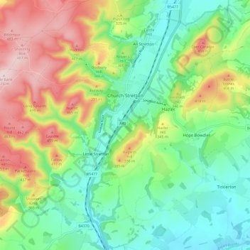
Name: Church Stretton topographic map, elevation, terrain.

Location: Church Stretton, Shropshire, England, United Kingdom (52.49558 -2.87889 52.56571 -2.76700)

Average elevation: 919 ft

Minimum elevation: 479 ft

Maximum elevation: 1,683 ft

Other topographic maps

Click on a map to view its topography, its elevation and its terrain.

Fitz

United Kingdom > England > Shropshire

Average elevation: 243 ft

Aston Munslow

United Kingdom > England > Shropshire

Average elevation: 551 ft

Onston

United Kingdom > England > Shropshire > Tetchill

Average elevation: 315 ft

Selattyn

United Kingdom > England > Shropshire

Average elevation: 794 ft

Alveley

United Kingdom > England > Shropshire

Average elevation: 335 ft

Chirbury

United Kingdom > England > Shropshire

Average elevation: 410 ft

Wem

United Kingdom > England > Shropshire

Average elevation: 289 ft

Oldbury

United Kingdom > England > Shropshire > Bridgnorth

Average elevation: 262 ft

Homer

United Kingdom > England > Shropshire > Much Wenlock

Average elevation: 427 ft

Walford

United Kingdom > England > Shropshire

Average elevation: 272 ft

Ashford Carbonell

United Kingdom > England > Shropshire

Average elevation: 285 ft

Cedars of Lebanon

United Kingdom > England > Shropshire > Atcham

Average elevation: 171 ft

Gear up for your next adventure:

Backpacking Tent - Lightweight and durable tent for multi‑day hikes
🧥Men's Rain Shells - Premium waterproof and breathable jackets for mountain weather
📻Weather Alert Radios - Stay informed of storm risks while off-the-grid
🛠️Outdoor Gear Repair Kit - Essential tools to fix gear on the trail
🚑Emergency Bivvies - Heat-reflective sleeping bags for survival situations

As an Amazon Associate, this site earns from qualifying purchases at no extra cost to you.