Geolocate

Broseley topographic map

Click on the map to display elevation.

About this map

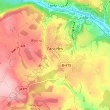
Name: Broseley topographic map, elevation, terrain.

Location: Broseley, Shropshire, England, United Kingdom (52.59736 -2.48888 52.62508 -2.42729)

Average elevation: 466 ft

Minimum elevation: 125 ft

Maximum elevation: 715 ft

Other topographic maps

Click on a map to view its topography, its elevation and its terrain.

Onston

United Kingdom > England > Shropshire > Tetchill

Average elevation: 315 ft

Fitz

United Kingdom > England > Shropshire

Average elevation: 243 ft

Homer

United Kingdom > England > Shropshire > Much Wenlock

Average elevation: 427 ft

Wem

United Kingdom > England > Shropshire

Average elevation: 289 ft

Aston Munslow

United Kingdom > England > Shropshire

Average elevation: 551 ft

Chirbury

United Kingdom > England > Shropshire

Average elevation: 410 ft

Oldbury

United Kingdom > England > Shropshire > Bridgnorth

Average elevation: 262 ft

Ashford Carbonell

United Kingdom > England > Shropshire

Average elevation: 285 ft

Alveley

United Kingdom > England > Shropshire

Average elevation: 335 ft

Selattyn

United Kingdom > England > Shropshire

Average elevation: 794 ft

Walford

United Kingdom > England > Shropshire

Average elevation: 272 ft

Cedars of Lebanon

United Kingdom > England > Shropshire > Atcham

Average elevation: 171 ft

Gear up for your next adventure:

🪶Multi‑Purpose Knife - Useful blade for camp and trail
🧯Emergency Survival Kit - All‑in‑one survival essentials for the backcountry
🔭Compact Binoculars - HD vision for scouting terrain and identifying distant landmarks
😴Insulated Sleeping Pads - Compact and warm pads for high-elevation camping
🔥Camping Stove - Portable stove for camping and backcountry cooking

As an Amazon Associate, this site earns from qualifying purchases at no extra cost to you.