
Embarcadero Marina Park topographic map
Interactive map
Click on the map to display elevation.
About this map
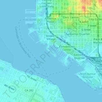
Name: Embarcadero Marina Park topographic map, elevation, terrain.
Average elevation: 23 ft
Minimum elevation: -3 ft
Maximum elevation: 174 ft
Other topographic maps
Click on a map to view its topography, its elevation and its terrain.
San Diego
United States > California > San Diego County > San Diego
San Diego, San Diego County, California, 92101, United States
Average elevation: 187 ft
La Jolla
United States > California > San Diego County > San Diego > La Jolla
La Jolla, San Diego, San Diego County, California, 92037, United States
Average elevation: 121 ft
Balboa Park
United States > California > San Diego County > San Diego
Balboa Park, San Diego, San Diego County, California, United States
Average elevation: 240 ft
East Village
United States > California > San Diego County > San Diego
East Village, San Diego, San Diego County, California, United States
Average elevation: 79 ft
Balboa Park
United States > California > San Diego County > San Diego
Balboa Park, San Diego, San Diego County, California, 92134, United States
Average elevation: 233 ft
Allied Gardens
United States > California > San Diego County > San Diego
Allied Gardens, San Diego, San Diego County, CAL Fire Southern Region, California, 92120, United States
Average elevation: 292 ft
San Diego River
United States > California > San Diego County > San Diego
San Diego River, San Diego, San Diego County, California, 92120, United States
Average elevation: 587 ft
Rancho Peñasquitos
United States > California > San Diego County > San Diego
Rancho Peñasquitos, San Diego, San Diego County, California, 92129, United States
Average elevation: 515 ft
Del Cerro
United States > California > San Diego County > San Diego
Del Cerro, San Diego, San Diego County, California, 92120, United States
Average elevation: 453 ft
Lake Hodges
United States > California > San Diego County > San Diego
Lake Hodges, San Diego, San Diego County, CAL Fire Southern Region, California, United States
Average elevation: 509 ft
Darnall
United States > California > San Diego County > San Diego
Darnall, San Diego, San Diego County, California, 92115, United States
Average elevation: 387 ft
Cowles Mountain
United States > California > San Diego County > San Diego
Cowles Mountain, San Diego, San Diego County, California, 92119, United States
Average elevation: 814 ft
Old Town San Diego State Historical Park
United States > California > San Diego County > San Diego
Old Town San Diego State Historical Park, Old Town, San Diego, San Diego County, CAL Fire Southern Region, California, 92110, United States
Average elevation: 59 ft
San Ysidro
United States > California > San Diego County > San Diego
San Ysidro, San Diego, San Diego County, California, 92173, United States
Average elevation: 138 ft
Carmel Mountain
United States > California > San Diego County > San Diego
Carmel Mountain, San Diego, San Diego County, California, 92130, United States
Average elevation: 246 ft
Sorrento Valley
United States > California > San Diego County > San Diego
Sorrento Valley, San Diego, San Diego County, California, 92121, United States
Average elevation: 289 ft
Los Peñasquitos Canyon Preserve
United States > California > San Diego County > San Diego > Sorrento Valley
Los Peñasquitos Canyon Preserve, Sorrento Valley, San Diego, San Diego County, California, United States
Average elevation: 312 ft
South Encanto
United States > California > San Diego County > San Diego > South Encanto
South Encanto, San Diego, San Diego County, California, 92114, United States
Average elevation: 262 ft
Colina Park
United States > California > San Diego County > San Diego > Colina Park
Colina Park, San Diego, San Diego County, California, 92105, United States
Average elevation: 361 ft
South Rim
United States > California > San Diego County > San Diego
South Rim, Otay Mesa, San Diego, San Diego County, California, 92173, United States
Average elevation: 335 ft
Rolando
United States > California > San Diego County > San Diego > Rolando
Rolando, San Diego, San Diego County, California, 92115, United States
Average elevation: 433 ft
Alta Vista
United States > California > San Diego County > San Diego > Alta Vista
Alta Vista, San Diego, San Diego County, California, 92114, United States
Average elevation: 266 ft
San Carlos
United States > California > San Diego County > San Diego
San Carlos, San Diego, San Diego County, California, 92119, United States
Average elevation: 679 ft
Valencia Park
United States > California > San Diego County > San Diego > Valencia Park
Valencia Park, San Diego, San Diego County, California, 92102-4810, United States
Average elevation: 184 ft
Kendall-Frost Mission Bay Marsh Reserve
United States > California > San Diego County > San Diego
Kendall-Frost Mission Bay Marsh Reserve, Egret Crescent, Pacific Beach, San Diego, San Diego County, California, 92109, United States
Average elevation: 30 ft