
Balboa Park topographic map
Click on the map to display elevation.
About this map
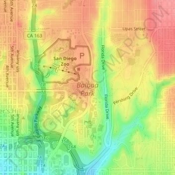
Name: Balboa Park topographic map, elevation, terrain.
Average elevation: 240 ft
Minimum elevation: 79 ft
Maximum elevation: 354 ft
San Diego County trails, hiking, mountain biking, running and outdoor activities
Other topographic maps
Click on a map to view its topography, its elevation and its terrain.
San Diego
United States > California > San Diego County > San Diego
The climate in San Diego, like most of Southern California, often varies significantly over short geographical distances, resulting in microclimates. In San Diego, this is mostly because of the city's topography (the Bay, and the numerous hills, mountains, and canyons). Frequently, particularly during the "May…
Average elevation: 187 ft
Lake Murray Reservoir
United States > California > San Diego County > San Diego > San Carlos
Average elevation: 584 ft
Rancho Peñasquitos
United States > California > San Diego County > San Diego
The highest point in the community is Black Mountain, which rises to an elevation of 1,500 feet (460 m).
Average elevation: 515 ft
Torrey Pines State Natural Reserve
United States > California > San Diego County > San Diego
Average elevation: 121 ft
La Jolla Shores Beach
United States > California > San Diego County > San Diego
Average elevation: 128 ft
La Jolla
United States > California > San Diego County > San Diego > La Jolla
Average elevation: 121 ft