
Make a donation
Gear up for your next adventure:
As an Amazon Associate, this site earns from qualifying purchases at no extra cost to you.
Morin-Heights topographic map
Click on the map to display elevation.
Make a donation
Gear up for your next adventure:
As an Amazon Associate, this site earns from qualifying purchases at no extra cost to you.
About this map
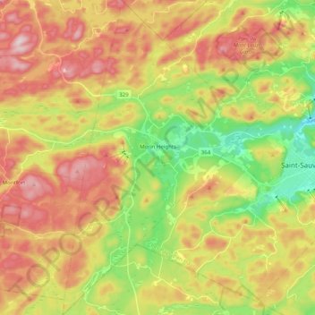
Name: Morin-Heights topographic map, elevation, terrain.
Average elevation: 1,142 ft
Minimum elevation: 558 ft
Maximum elevation: 1,752 ft
Make a donation
Gear up for your next adventure:
As an Amazon Associate, this site earns from qualifying purchases at no extra cost to you.
Other topographic maps
Click on a map to view its topography, its elevation and its terrain.
Lac Saint-Louis
Canada > Quebec > Les Pays-d'en-Haut > Sainte-Marguerite-du-Lac-Masson
Average elevation: 1,453 ft
Make a donation
Gear up for your next adventure:
As an Amazon Associate, this site earns from qualifying purchases at no extra cost to you.
Domaine-Alpine
Canada > Quebec > Les Pays-d'en-Haut > Saint-Adolphe-d'Howard
Average elevation: 1,283 ft
Make a donation
Gear up for your next adventure:
As an Amazon Associate, this site earns from qualifying purchases at no extra cost to you.
Lac Valiquette
Canada > Quebec > Les Pays-d'en-Haut > Saint-Adolphe-d'Howard
Average elevation: 1,490 ft
parc Île Benoit
Canada > Quebec > Les Pays-d'en-Haut > Sainte-Anne-des-Lacs
Average elevation: 1,040 ft
Saint-Michel-de-Wentworth
Canada > Quebec > Les Pays-d'en-Haut > Wentworth-Nord
Average elevation: 1,050 ft
Make a donation
Gear up for your next adventure:
As an Amazon Associate, this site earns from qualifying purchases at no extra cost to you.
Mont Edward
Canada > Quebec > Les Pays-d'en-Haut > Sainte-Marguerite-du-Lac-Masson
Average elevation: 1,414 ft
Lac Marier
Canada > Quebec > Les Pays-d'en-Haut > Sainte-Marguerite-du-Lac-Masson
Average elevation: 1,237 ft
Make a donation
Gear up for your next adventure:
As an Amazon Associate, this site earns from qualifying purchases at no extra cost to you.