Geolocate

Macomb topographic map

Click on the map to display elevation.

About this map

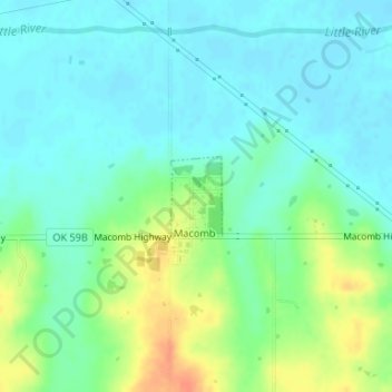
Name: Macomb topographic map, elevation, terrain.

Location: Macomb, Pottawatomie County, Oklahoma, United States (35.14522 -97.01086 35.15075 -97.00650)

Average elevation: 965 ft

Minimum elevation: 922 ft

Maximum elevation: 1,063 ft

Pottawatomie County trails, hiking, mountain biking, running and outdoor activities

Other topographic maps

Click on a map to view its topography, its elevation and its terrain.

Macomb

United States > Oklahoma > Pottawatomie County > Macomb

Average elevation: 978 ft

Centerview

United States > Oklahoma > Pottawatomie County

Average elevation: 961 ft

Harjo

United States > Oklahoma > Pottawatomie County

Average elevation: 932 ft

Trousdale

United States > Oklahoma > Pottawatomie County

Average elevation: 997 ft

Gear up for your next adventure:

🛶Inflatable Kayak - Portable kayak for rivers, lakes, and expeditions
🩹Survival Bandages - High‑quality bandages for emergencies
📌Outdoor GPS Map App - Apps and devices for digital topographic navigation
🔋Solar Power Banks - Keep your GPS and phone charged in remote wilderness areas
⛑️Personal Locator Beacon - Safety beacon for emergencies

As an Amazon Associate, this site earns from qualifying purchases at no extra cost to you.