Geolocate

Tioga State Forest topographic map

Click on the map to display elevation.

About this map

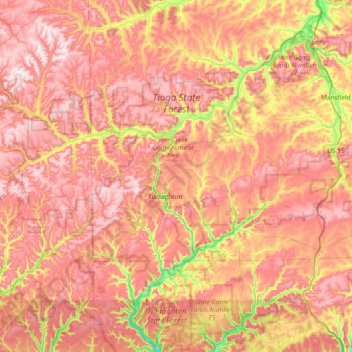
Name: Tioga State Forest topographic map, elevation, terrain.

Location: Tioga State Forest, Tioga County, Pennsylvania, United States (41.51318 -77.60916 41.84530 -76.85593)

Average elevation: 1,788 ft

Minimum elevation: 676 ft

Maximum elevation: 2,595 ft

Tioga County trails, hiking, mountain biking, running and outdoor activities

Other topographic maps

Click on a map to view its topography, its elevation and its terrain.

Williard

United States > Pennsylvania > Tioga County

Average elevation: 1,877 ft

Hartsfield

United States > Pennsylvania > Tioga County

Average elevation: 1,785 ft

Bear Run

United States > Pennsylvania > Tioga County > Landrus

Average elevation: 1,706 ft

Gaines

United States > Pennsylvania > Tioga County

Average elevation: 1,677 ft

Sebring

United States > Pennsylvania > Tioga County > Sebring

Average elevation: 1,909 ft

Gobblers Knob

United States > Pennsylvania > Tioga County

Average elevation: 1,755 ft

Gear up for your next adventure:

🧦Hiking Socks - Comfortable socks to prevent blisters on long hikes
🎁Geography Themed Gifts - Unique gift ideas for map lovers and geography enthusiasts
🕶️Glacier Sunglasses - Side shields to protect eyes from high-altitude snow glare
🧤Tactile Hiking Gloves - Keep hands warm while operating GPS and smartphone screens
🧭Pro Hiking Compasses - High-accuracy liquid-filled compasses for topographic orientation

As an Amazon Associate, this site earns from qualifying purchases at no extra cost to you.