Erfurt topographic map
Click on the map to display elevation.
Erfurt
Erfurt is situated in the south of the Thuringian basin, a fertile agricultural area between the Harz mountains 80 km (50 mi) to the north and the Thuringian forest 30 km (19 mi) to the southwest. Whereas the northern parts of the city area are flat, the southern ones consist of hilly landscape up to 430 m of elevation. In this part lies the municipal forest of Steigerwald with beeches and oaks as main tree species. To the east and to the west are some non-forested hills so that the Gera river valley within the town forms a basin. North of the city are some gravel pits in operation, while others are abandoned, flooded and used as leisure areas.
About this map
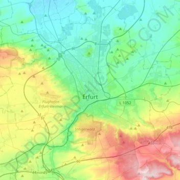
Name: Erfurt topographic map, elevation, terrain.
Location: Erfurt, Thuringia, Germany (50.89049 10.85467 51.07988 11.17514)
Average elevation: 823 ft
Minimum elevation: 502 ft
Maximum elevation: 1,624 ft
Other topographic maps
Click on a map to view its topography, its elevation and its terrain.


Wohnsiedlung Am Flugplatz
Germany > Thuringia > Unstrut-Hainich-Kreis > Obermehler
Average elevation: 883 ft
Jena
Jena is situated in a hilly landscape in eastern Thuringia at the Saale river, between the Harz mountains 85 km (53 mi) in the north, the Thuringian Forest/Thuringian Highland 50 km (31 mi) in the southwest and the Ore Mountains, 75 km (47 mi) in the southeast. The municipal terrain is hilly with rugged slopes…
Average elevation: 948 ft

Hinter den Lieden
Germany > Thuringia > Landkreis Sömmerda > Riethnordhausen
Average elevation: 545 ft



Rotterode
Germany > Thuringia > Landkreis Schmalkalden-Meiningen > Steinbach-Hallenberg
Average elevation: 1,870 ft

Birkenfeld
Germany > Thuringia > Landkreis Hildburghausen > Hildburghausen
Average elevation: 1,371 ft


Unterburg
Germany > Thuringia > Kyffhäuserkreis > Kyffhäuserland > Kohlstätte
Average elevation: 988 ft