
Fallston topographic map
Click on the map to display elevation.
About this map
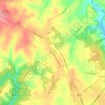
Name: Fallston topographic map, elevation, terrain.
Location: Fallston, Harford County, Maryland, 21047, United States (39.49455 -76.43107 39.53455 -76.39107)
Average elevation: 417 ft
Minimum elevation: 217 ft
Maximum elevation: 564 ft
Harford County trails, hiking, mountain biking, running and outdoor activities
Other topographic maps
Click on a map to view its topography, its elevation and its terrain.
Darlington
United States > Maryland > Harford County > Darlington > Hopkins Corner
Average elevation: 289 ft
Aberdeen Proving Ground
United States > Maryland > Harford County > Aberdeen Proving Ground
Average elevation: 23 ft