Geolocate

Leopold topographic map

Click on the map to display elevation.

About this map

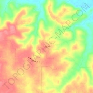
Name: Leopold topographic map, elevation, terrain.

Location: Leopold, Bollinger County, Missouri, 63760, United States (37.23783 -89.94649 37.27783 -89.90649)

Average elevation: 548 ft

Minimum elevation: 374 ft

Maximum elevation: 673 ft

Bollinger County trails, hiking, mountain biking, running and outdoor activities

Other topographic maps

Click on a map to view its topography, its elevation and its terrain.

Zalma

United States > Missouri > Bollinger County

Average elevation: 404 ft

Sedgewickville

United States > Missouri > Bollinger County

Average elevation: 614 ft

Glen Allen

United States > Missouri > Bollinger County

Average elevation: 525 ft

Gear up for your next adventure:

🧭Hiking Compass - Precision compass for reliable navigation in the wilderness
🪑Ultralight Camp Chairs - Portable seating for resting after a long day of mapping
📡Handheld GPS Device - Reliable handheld GPS for outdoor navigation
🛡️Insect Repellent - Protection against bugs during outdoor activities
📷Action Camera - Capture your outdoor adventures in HD

As an Amazon Associate, this site earns from qualifying purchases at no extra cost to you.