Geolocate

Whitewater River topographic map

Click on the map to display elevation.

About this map

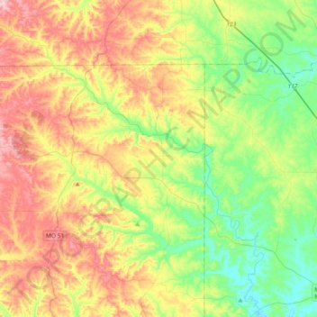
Name: Whitewater River topographic map, elevation, terrain.

Location: Whitewater River, Bollinger County, Missouri, United States (37.36819 -90.12157 37.65811 -89.79498)

Average elevation: 633 ft

Minimum elevation: 381 ft

Maximum elevation: 991 ft

Bollinger County trails, hiking, mountain biking, running and outdoor activities

Other topographic maps

Click on a map to view its topography, its elevation and its terrain.

Leopold

United States > Missouri > Bollinger County

Average elevation: 548 ft

Mayfield

United States > Missouri > Bollinger County

Average elevation: 604 ft

Gipsy

United States > Missouri > Bollinger County

Average elevation: 495 ft

Zalma

United States > Missouri > Bollinger County

Average elevation: 404 ft

Sedgewickville

United States > Missouri > Bollinger County

Average elevation: 614 ft

Glen Allen

United States > Missouri > Bollinger County

Average elevation: 525 ft

Sturdivant

United States > Missouri > Bollinger County

Average elevation: 351 ft

Patton

United States > Missouri > Bollinger County

Average elevation: 656 ft

Gear up for your next adventure:

🥇GPS Hiking Watch - Multi‑sport GPS watch with navigation and trail tracking
🧺Microfiber Travel Towels - Compact and fast-drying towels for trail use
😴Insulated Sleeping Pads - Compact and warm pads for high-elevation camping
🧭GPS Watch Accessories - Bands and chargers for GPS watches
📱Heavy-Duty Phone Cases - Drop-proof and waterproof protection for outdoor navigation

As an Amazon Associate, this site earns from qualifying purchases at no extra cost to you.