Geolocate

Sedgewickville topographic map

Click on the map to display elevation.

About this map

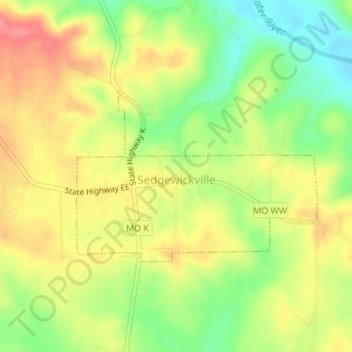
Name: Sedgewickville topographic map, elevation, terrain.

Location: Sedgewickville, Bollinger County, Missouri, United States (37.50987 -89.91671 37.52302 -89.89337)

Average elevation: 614 ft

Minimum elevation: 479 ft

Maximum elevation: 732 ft

Bollinger County trails, hiking, mountain biking, running and outdoor activities

Other topographic maps

Click on a map to view its topography, its elevation and its terrain.

Leopold

United States > Missouri > Bollinger County

Average elevation: 548 ft

Mayfield

United States > Missouri > Bollinger County

Average elevation: 604 ft

Gipsy

United States > Missouri > Bollinger County

Average elevation: 495 ft

Sturdivant

United States > Missouri > Bollinger County

Average elevation: 351 ft

Patton

United States > Missouri > Bollinger County

Average elevation: 656 ft

Gear up for your next adventure:

🧦Merino Wool Socks - Moisture-wicking, blister-preventing socks for long treks
GPS Sports Watch - GPS watch for running, hiking and training
🌲Outdoor Survival Books - Best books on survival skills
🎁Geography Themed Gifts - Unique gift ideas for map lovers and geography enthusiasts
🧯Portable Fire Pit - Compact fire pit for camping spots

As an Amazon Associate, this site earns from qualifying purchases at no extra cost to you.