
Make a donation
Gear up for your next adventure:
As an Amazon Associate, this site earns from qualifying purchases at no extra cost to you.
Little Thetford topographic map
Click on the map to display elevation.
Make a donation
Gear up for your next adventure:
As an Amazon Associate, this site earns from qualifying purchases at no extra cost to you.
About this map
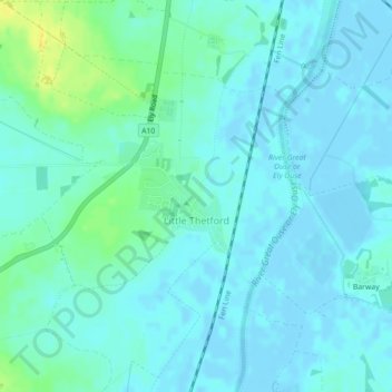
Name: Little Thetford topographic map, elevation, terrain.
Average elevation: 16 ft
Minimum elevation: -10 ft
Maximum elevation: 66 ft
Make a donation
Gear up for your next adventure:
As an Amazon Associate, this site earns from qualifying purchases at no extra cost to you.
Other topographic maps
Click on a map to view its topography, its elevation and its terrain.
Holme Fen
United Kingdom > England > Cambridgeshire > East Cambridgeshire > Haddenham
Average elevation: 13 ft
Little Ouse
United Kingdom > England > Cambridgeshire > East Cambridgeshire > Littleport
Average elevation: -3 ft
Make a donation
Gear up for your next adventure:
As an Amazon Associate, this site earns from qualifying purchases at no extra cost to you.
Westley Waterless
United Kingdom > England > Cambridgeshire > East Cambridgeshire
Average elevation: 302 ft
Make a donation
Gear up for your next adventure:
As an Amazon Associate, this site earns from qualifying purchases at no extra cost to you.
Little Downham
United Kingdom > England > Cambridgeshire > East Cambridgeshire
Average elevation: 16 ft
Make a donation
Gear up for your next adventure:
As an Amazon Associate, this site earns from qualifying purchases at no extra cost to you.
Chippenham
United Kingdom > England > Cambridgeshire > East Cambridgeshire > Chippenham
Average elevation: 72 ft
Rack Fen
United Kingdom > England > Cambridgeshire > East Cambridgeshire > Littleport
Average elevation: 0 ft
Make a donation
Gear up for your next adventure:
As an Amazon Associate, this site earns from qualifying purchases at no extra cost to you.
Little Thetford
United Kingdom > England > Cambridgeshire > East Cambridgeshire
Average elevation: 16 ft
Make a donation
Gear up for your next adventure:
As an Amazon Associate, this site earns from qualifying purchases at no extra cost to you.
Make a donation
Gear up for your next adventure:
As an Amazon Associate, this site earns from qualifying purchases at no extra cost to you.
Chippenham Fen NNR (permit access)
United Kingdom > England > Cambridgeshire > East Cambridgeshire
Average elevation: 56 ft
Queen Adelaide
United Kingdom > England > Cambridgeshire > East Cambridgeshire
Average elevation: 13 ft
Make a donation
Gear up for your next adventure:
As an Amazon Associate, this site earns from qualifying purchases at no extra cost to you.
Swaffham Prior
United Kingdom > England > Cambridgeshire > East Cambridgeshire
Average elevation: 36 ft
Make a donation
Gear up for your next adventure:
As an Amazon Associate, this site earns from qualifying purchases at no extra cost to you.
Stretham
United Kingdom > England > Cambridgeshire > East Cambridgeshire > Stretham
Average elevation: 13 ft
Make a donation
Gear up for your next adventure:
As an Amazon Associate, this site earns from qualifying purchases at no extra cost to you.
Coveney
United Kingdom > England > Cambridgeshire > East Cambridgeshire > Coveney
Average elevation: 7 ft
Swaffham Bulbeck
United Kingdom > England > Cambridgeshire > East Cambridgeshire
Average elevation: 46 ft
Make a donation
Gear up for your next adventure:
As an Amazon Associate, this site earns from qualifying purchases at no extra cost to you.
Witcham Toll
United Kingdom > England > Cambridgeshire > East Cambridgeshire > Witcham
Average elevation: 33 ft
Make a donation
Gear up for your next adventure:
As an Amazon Associate, this site earns from qualifying purchases at no extra cost to you.