
Little Downham topographic map
Click on the map to display elevation.
About this map
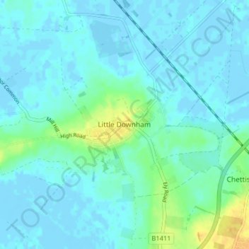
Name: Little Downham topographic map, elevation, terrain.
Average elevation: 16 ft
Minimum elevation: -13 ft
Maximum elevation: 82 ft
Other topographic maps
Click on a map to view its topography, its elevation and its terrain.
River Great Ouse or Ely Ouse
United Kingdom > England > Cambridgeshire > East Cambridgeshire > Soham > Stuntney
Average elevation: 13 ft
Barway
United Kingdom > England > Cambridgeshire > East Cambridgeshire > Soham
Average elevation: 7 ft
Westley Waterless
United Kingdom > England > Cambridgeshire > East Cambridgeshire
Average elevation: 302 ft
Chippenham
United Kingdom > England > Cambridgeshire > East Cambridgeshire > Chippenham
Average elevation: 72 ft
Coveney
United Kingdom > England > Cambridgeshire > East Cambridgeshire > Coveney
Average elevation: 7 ft
Stretham
United Kingdom > England > Cambridgeshire > East Cambridgeshire > Stretham
Average elevation: 13 ft
Little Thetford
United Kingdom > England > Cambridgeshire > East Cambridgeshire
Average elevation: 16 ft
Swaffham Prior
United Kingdom > England > Cambridgeshire > East Cambridgeshire
Average elevation: 36 ft
Swaffham Bulbeck
United Kingdom > England > Cambridgeshire > East Cambridgeshire
Average elevation: 46 ft