
Reach topographic map
Click on the map to display elevation.
About this map
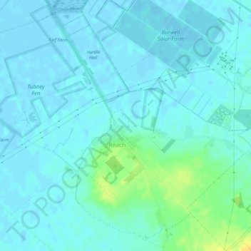
Name: Reach topographic map, elevation, terrain.
Average elevation: 13 ft
Minimum elevation: -10 ft
Maximum elevation: 69 ft
Other topographic maps
Click on a map to view its topography, its elevation and its terrain.
River Great Ouse or Ely Ouse
United Kingdom > England > Cambridgeshire > East Cambridgeshire > Soham > Stuntney
Average elevation: 13 ft
Barway
United Kingdom > England > Cambridgeshire > East Cambridgeshire > Soham
Average elevation: 7 ft
Holme Fen
United Kingdom > England > Cambridgeshire > East Cambridgeshire > Haddenham
Average elevation: 13 ft
Little Ouse
United Kingdom > England > Cambridgeshire > East Cambridgeshire > Littleport
Average elevation: -3 ft
Little Thetford
United Kingdom > England > Cambridgeshire > East Cambridgeshire
Average elevation: 16 ft
Little Downham
United Kingdom > England > Cambridgeshire > East Cambridgeshire
Average elevation: 16 ft
Rack Fen
United Kingdom > England > Cambridgeshire > East Cambridgeshire > Littleport
Average elevation: 0 ft
Little Thetford
United Kingdom > England > Cambridgeshire > East Cambridgeshire
Average elevation: 16 ft
Chippenham Fen NNR (permit access)
United Kingdom > England > Cambridgeshire > East Cambridgeshire
Average elevation: 56 ft
Queen Adelaide
United Kingdom > England > Cambridgeshire > East Cambridgeshire
Average elevation: 13 ft
Witcham Toll
United Kingdom > England > Cambridgeshire > East Cambridgeshire > Witcham
Average elevation: 33 ft