
Make a donation
Gear up for your next adventure:
As an Amazon Associate, this site earns from qualifying purchases at no extra cost to you.
Saint Petersburg topographic map
Click on the map to display elevation.
Make a donation
Gear up for your next adventure:
As an Amazon Associate, this site earns from qualifying purchases at no extra cost to you.
Saint Petersburg
The elevation of Saint Petersburg ranges from the sea level to its highest point of 175.9 metres (577 feet) at the Orekhovaya Hill in the Duderhof Heights in the south. Part of the city's territory west of Liteyny Prospekt is no higher than 4 m (13 ft) above sea level, and has suffered from numerous floods. Floods in Saint Petersburg are triggered by a long wave in the Baltic Sea, caused by meteorological conditions, winds, and shallowness of the Neva Bay. The five most disastrous floods occurred in 1824 (4.21 metres or 13 feet 10 inches above sea level, during which over 300 buildings were destroyed); 1924 (3.8 m, 12 ft 6 in); 1777 (3.21 m, 10 ft 6 in); 1955 (2.93 m, 9 ft 7 in); and 1975 (2.81 m, 9 ft 3 in). To prevent floods, the Saint Petersburg Dam has been constructed.
Make a donation
Gear up for your next adventure:
As an Amazon Associate, this site earns from qualifying purchases at no extra cost to you.
About this map
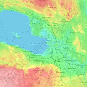
Name: Saint Petersburg topographic map, elevation, terrain.
Location: Saint Petersburg, Northwestern Federal District, Russia (59.63378 29.42576 60.24484 30.75949)
Average elevation: 131 ft
Minimum elevation: -23 ft
Maximum elevation: 561 ft
Make a donation
Gear up for your next adventure:
As an Amazon Associate, this site earns from qualifying purchases at no extra cost to you.
Other topographic maps
Click on a map to view its topography, its elevation and its terrain.
Sochi
Russia > Krasnodar Krai > Resort Town of Sochi (municipal formation)
Sochi has a humid subtropical climate (Köppen climate classification Cfa), at the lower elevations. Its average annual temperature is 18.9 °C (66.0 °F) during the day and 11.5 °C (52.7 °F) at night. In the coldest months—January and February—the average temperature is about 10 °C (50 °F) during the…
Average elevation: 486 ft
Moscow
Moscow is situated on the banks of the Moskva River, which flows for just over 500 km (311 mi) through the East European Plain in central Russia, not far from the natural border of the forest and forest-steppe zone. 49 bridges span the river and its canals within the city's limits. The elevation of Moscow at…
Average elevation: 522 ft
Mount Elbrus (West Summit)
Russia > Karachay-Cherkessia > Karachayevsky District
As Elbrus is located in the Northern Hemisphere, the summer period takes place from June to mid-September, with an average of 50% of sunny days favorable to the ascent of the summit. However, the winds, dominated by westerly air masses, can turn violent and temperatures drop very quickly. Above 4000 meters…
Average elevation: 16,932 ft
Make a donation
Gear up for your next adventure:
As an Amazon Associate, this site earns from qualifying purchases at no extra cost to you.
Make a donation
Gear up for your next adventure:
As an Amazon Associate, this site earns from qualifying purchases at no extra cost to you.
Siberia
Russia > Krasnoyarsk Krai > Boguchansky Rayon
Eastern and central Sakha comprises numerous north–south mountain ranges of various ages. These mountains extend up to almost 3,000 metres (9,800 ft), but above a few hundred metres they are almost completely devoid of vegetation. The Verkhoyansk Range was extensively glaciated in the Pleistocene, but the…
Average elevation: 1,135 ft
Ural Mountains
Russia > Khanty-Mansiysk Autonomous Okrug – Ugra > Beryozovsky District
The Ural Mountains (/ˈjʊərəl/ YOOR-əl; Russian: Ура́льские го́ры, tr. Uralskiye gory, IPA: [ʊˈralʲskʲɪjə ˈɡorɨ]; Bashkir: Урал тауҙары) or simply the Urals, are a mountain range in Eurasia that runs north-south mostly through Russia, from the coast of the Arctic Ocean to…
Average elevation: 4,708 ft
Make a donation
Gear up for your next adventure:
As an Amazon Associate, this site earns from qualifying purchases at no extra cost to you.
Mount Yamantau
Russia > Bashkortostan > Beloretsky District
Up to 1,000–1,100 m elevation, the mountain slope is covered with mixed forest, in some places with driftwood, occasional alpine meadows and rocky outcrops. Above 1,100 m elevation, there are no trees or bushes, and instead rock streams of various sizes, with grass, flowers and moss start to appear.
Average elevation: 4,377 ft
Make a donation
Gear up for your next adventure:
As an Amazon Associate, this site earns from qualifying purchases at no extra cost to you.
Make a donation
Gear up for your next adventure:
As an Amazon Associate, this site earns from qualifying purchases at no extra cost to you.
Make a donation
Gear up for your next adventure:
As an Amazon Associate, this site earns from qualifying purchases at no extra cost to you.
Dzhugdzhur Mountains
Russia > Khabarovsk Krai > Ayano-Maysky Rayon
The coastal stretch of the range is populated by Japanese stone pine and Dahurian larch. Parts of the range occupied by the Okhotsk-Manchurian taiga ecoregion contain swathes of Jezo spruce up to elevations of 1,300 m.
Average elevation: 5,131 ft
Make a donation
Gear up for your next adventure:
As an Amazon Associate, this site earns from qualifying purchases at no extra cost to you.
Шаранча
Russia > Zabaykalsky Krai > Alexandrovo-Zavodsky District > Шаранча
Average elevation: 2,680 ft
Make a donation
Gear up for your next adventure:
As an Amazon Associate, this site earns from qualifying purchases at no extra cost to you.
Make a donation
Gear up for your next adventure:
As an Amazon Associate, this site earns from qualifying purchases at no extra cost to you.
Make a donation
Gear up for your next adventure:
As an Amazon Associate, this site earns from qualifying purchases at no extra cost to you.
Верхнеказымский
Russia > Khanty-Mansiysk Autonomous Okrug – Ugra > Beloyarsky District
Average elevation: 131 ft
Make a donation
Gear up for your next adventure:
As an Amazon Associate, this site earns from qualifying purchases at no extra cost to you.
Make a donation
Gear up for your next adventure:
As an Amazon Associate, this site earns from qualifying purchases at no extra cost to you.
Central Caucasian Ridge
Russia > Kabardino-Balkaria > Cherek District > Verkhnyaya Balkariya
The highest and rockiest section of the range is located in its central part. Although not as high as the topmost summits of the Lateral Range to the north, the highest elevations of the Main Caucasian Range include the 5,193 meters (17,037 ft) high Shkhara, the 4,466 meters (14,652 ft) high Mount Bazardüzü…
Average elevation: 9,134 ft
Make a donation
Gear up for your next adventure:
As an Amazon Associate, this site earns from qualifying purchases at no extra cost to you.
озеро Коробейниково
Russia > Sverdlovsk Oblast > Тавдинский муниципальный округ > Азанка
Average elevation: 236 ft
Make a donation
Gear up for your next adventure:
As an Amazon Associate, this site earns from qualifying purchases at no extra cost to you.
Make a donation
Gear up for your next adventure:
As an Amazon Associate, this site earns from qualifying purchases at no extra cost to you.
Kruzenshtern
Russia > Arkhangelsk Oblast > Novaya Zemlya Urban Okrug
The mountain was first put on the map in the 1820s by Arctic explorer Fyodor Litke (1797–1882) following his Novaya Zemlya explorations. It was named after Imperial Russian Navy Admiral Ivan Kruzenshtern (1770–1846). The mountain's name must have been known to Soviet topographers, but for undisclosed…
Average elevation: 3,432 ft
Lokosovo
Russia > Khanty-Mansiysk Autonomous Okrug – Ugra > Surgutsky District
Average elevation: 138 ft
Make a donation
Gear up for your next adventure:
As an Amazon Associate, this site earns from qualifying purchases at no extra cost to you.
Тюли
Russia > Khanty-Mansiysk Autonomous Okrug – Ugra > Khanty-Mansiysky District
Average elevation: 89 ft
Малкинские горячие источники
Russia > Kamchatka Krai > Yelizovsky District
Average elevation: 1,037 ft
Make a donation
Gear up for your next adventure:
As an Amazon Associate, this site earns from qualifying purchases at no extra cost to you.
Verkhoyansk
Russia > Sakha Republic > Verkhoyansky Ulus
In this area, temperature inversions consistently form in winter due to the extremely cold and dense air of the Siberian High pooling in deep hollows, so that temperatures increase rather than decrease with higher altitude. In Verkhoyansk it sometimes happens that the average minimum temperatures for January,…
Average elevation: 459 ft
Make a donation
Gear up for your next adventure:
As an Amazon Associate, this site earns from qualifying purchases at no extra cost to you.
Make a donation
Gear up for your next adventure:
As an Amazon Associate, this site earns from qualifying purchases at no extra cost to you.
Make a donation
Gear up for your next adventure:
As an Amazon Associate, this site earns from qualifying purchases at no extra cost to you.
Make a donation
Gear up for your next adventure:
As an Amazon Associate, this site earns from qualifying purchases at no extra cost to you.
Vaygach polar station
Russia > Nenets Autonomous Okrug > Zapolyarny District
Vaygach Island is mainly formed of argillaceous slates, sandstone, and limestone. There are many rivers about 20–40 kilometres (12–25 mi) in length, swamps, and small lakes on the island. For the most part it consists of tundra. Slight rocky ridges run generally along its length, and the coast has low…
Average elevation: 39 ft
Make a donation
Gear up for your next adventure:
As an Amazon Associate, this site earns from qualifying purchases at no extra cost to you.
Make a donation
Gear up for your next adventure:
As an Amazon Associate, this site earns from qualifying purchases at no extra cost to you.
Make a donation
Gear up for your next adventure:
As an Amazon Associate, this site earns from qualifying purchases at no extra cost to you.
Oymyakon
Russia > Sakha Republic > Oymyakonsky Ulus
With an extreme subarctic climate (Köppen climate classification Dfd), Oymyakon is known as one of the places considered the Northern Pole of Cold, the other being the town of Verkhoyansk, located 629 km (391 mi) away by air. The weather station is in a valley between Oymyakon and Tomtor. The station is at…
Average elevation: 2,228 ft
Franz Josef Land
Russia > Arkhangelsk Oblast > Primorsky District
Approximately 85% of the archipelago is glaciated, with large unglaciated areas on the largest islands and many of the smallest ones. The islands have a combined coastline of 4,425 kilometers (2,750 mi). Compared to other Arctic archipelagos, Franz Josef Land is highly dissected, as a result of it being heavy…
Average elevation: 131 ft
Make a donation
Gear up for your next adventure:
As an Amazon Associate, this site earns from qualifying purchases at no extra cost to you.