Geolocate

Cheste topographic map

Click on the map to display elevation.

About this map

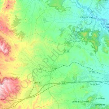
Name: Cheste topographic map, elevation, terrain.

Location: Cheste, La Hoya de Buñol, Valencia, Valencian Community, 46380, Spain (39.47103 -0.79529 39.55630 -0.58860)

Average elevation: 804 ft

Minimum elevation: 249 ft

Maximum elevation: 2,156 ft

Other topographic maps

Click on a map to view its topography, its elevation and its terrain.

Valencia

Spain > Valencian Community > Valencia > Valencia

Average elevation: 144 ft

Pedralba

Spain > Valencian Community > La Serranía > Pedralba

Average elevation: 581 ft

Alcossebre

Spain > Valencian Community

Average elevation: 131 ft

Santa Bàrbera

Spain > Valencian Community > Sant Mateu

Average elevation: 1,086 ft

Moraira

Spain > Valencian Community

Average elevation: 131 ft

Puntal de Aleto

Spain > Valencian Community > Chelva

Average elevation: 3,025 ft

Oliva

Spain > Valencian Community > Oliva > Oliva

Average elevation: 167 ft

Tous

Spain > Valencian Community > Tous > Tous

Average elevation: 390 ft

Calp

Spain > Valencian Community > Calp > Calp

Average elevation: 243 ft

San Juan

Spain > Valencian Community > Alicante

Average elevation: 361 ft

Gear up for your next adventure:

🧥Waterproof Jacket for Hiking - Breathable and rugged rain jacket for outdoor excursions
🪵Folding Camp Saw - Compact saw for wood and campsite work
🏔️Mountain Trail Maps - High‑detail maps for popular peaks
🗻Climbing Gear Basics - Essential gear for beginner climbers
🦶Hiking Gaiters - Keep debris and water out of your boots

As an Amazon Associate, this site earns from qualifying purchases at no extra cost to you.