Geolocate

Subbiano topographic map

Click on the map to display elevation.

About this map

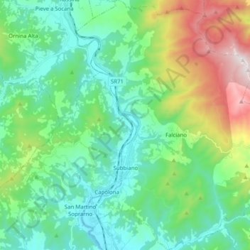
Name: Subbiano topographic map, elevation, terrain.

Location: Subbiano, Arezzo, Tuscany, Italy (43.53776 11.83866 43.65014 11.96847)

Average elevation: 1,755 ft

Minimum elevation: 761 ft

Maximum elevation: 4,619 ft

Other topographic maps

Click on a map to view its topography, its elevation and its terrain.

Portole

Italy > Tuscany > Arezzo > Cortona

Average elevation: 2,556 ft

Soci

Italy > Tuscany > Arezzo > Bibbiena

Average elevation: 1,493 ft

Giona

Italy > Tuscany > Arezzo > Bibbiena

Average elevation: 2,352 ft

Vitiano

Italy > Tuscany > Arezzo > Arezzo > Rigutino

Average elevation: 961 ft

Pulicciano

Italy > Tuscany > Arezzo

Average elevation: 1,693 ft

Pierle

Italy > Tuscany > Arezzo > Cortona

Average elevation: 1,867 ft

Alberoro

Italy > Tuscany > Arezzo

Average elevation: 843 ft

Caiano

Italy > Tuscany > Arezzo

Average elevation: 2,749 ft

Consuma

Italy > Tuscany > Arezzo > Montemignaio

Average elevation: 3,107 ft

Siregiolo

Italy > Tuscany > Arezzo > Chiusi della Verna

Average elevation: 2,359 ft

Montalto

Italy > Tuscany > Arezzo

Average elevation: 794 ft

Castelluccio

Italy > Tuscany > Arezzo

Average elevation: 853 ft

Cortina

Italy > Tuscany > Arezzo

Average elevation: 2,530 ft

Gear up for your next adventure:

🪶Thermal Camp Blanket - Extra warmth for cold nights
🛰️Satellite Messengers - Emergency SOS and two-way messaging for off-grid adventures
Camping Coffee Makers - Enjoy premium coffee at the summit or campsite
🧤Hiking Gloves - Protective gloves for rugged trails
🔭Compact Binoculars - HD vision for scouting terrain and identifying distant landmarks

As an Amazon Associate, this site earns from qualifying purchases at no extra cost to you.