Geolocate

Inwangsan (Mt.) topographic map

Click on the map to display elevation.

About this map

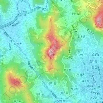
Name: Inwangsan (Mt.) topographic map, elevation, terrain.

Location: Inwangsan (Mt.), Seoul, 03635, South Korea (37.58493 126.95784 37.58503 126.95794)

Average elevation: 371 ft

Minimum elevation: 121 ft

Maximum elevation: 1,066 ft

Other topographic maps

Click on a map to view its topography, its elevation and its terrain.

Gangbuk-gu

South Korea > Seoul

Average elevation: 456 ft

Banghwa 1(il)-dong

South Korea > Seoul

Average elevation: 52 ft

Sinsa-dong

South Korea > Seoul

Average elevation: 95 ft

Dobong-gu

South Korea > Seoul

Average elevation: 394 ft

Guro-gu

South Korea > Seoul

Average elevation: 92 ft

Nowon-gu

South Korea > Seoul

Average elevation: 325 ft

Geumcheon-gu

South Korea > Seoul

Average elevation: 184 ft

Mangu-dong

South Korea > Seoul > Mangu-dong

Average elevation: 246 ft

Gangseo-gu

South Korea > Seoul

Average elevation: 72 ft

Sageun-dong

South Korea > Seoul > Seongdong-gu > Sageun-dong

Average elevation: 69 ft

Ihwa-dong

South Korea > Seoul > Jongno-gu > Ihwa-dong

Average elevation: 157 ft

Yeongdeungpo-gu

South Korea > Seoul

Average elevation: 66 ft

Bangbae-dong

South Korea > Seoul > Seocho-gu > Bangbae-dong

Average elevation: 259 ft

Hoegi-dong

South Korea > Seoul > Dongdaemun-gu > Hoegi-dong

Average elevation: 118 ft

Segok-dong

South Korea > Seoul > Gangnam-gu > Segok-dong

Average elevation: 141 ft

Samcheong-dong

South Korea > Seoul > Jongno-gu

Average elevation: 312 ft

Gear up for your next adventure:

🗻Climbing Gear Basics - Essential gear for beginner climbers
🔋Solar Power Banks - Keep your GPS and phone charged in remote wilderness areas
🎒Trail Energy Bars - High‑calorie bars for hiking energy
🔌Solar Panel Charger - Charge gear sustainably outdoors
🌲Outdoor Survival Books - Best books on survival skills

As an Amazon Associate, this site earns from qualifying purchases at no extra cost to you.