Geolocate

Midway topographic map

Click on the map to display elevation.

About this map

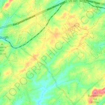
Name: Midway topographic map, elevation, terrain.

Location: Midway, Washington County, East Tennessee, Tennessee, United States (36.26063 -82.46116 36.31282 -82.39790)

Average elevation: 1,804 ft

Minimum elevation: 1,677 ft

Maximum elevation: 1,985 ft

Washington County trails, hiking, mountain biking, running and outdoor activities

Other topographic maps

Click on a map to view its topography, its elevation and its terrain.

Broylesville

United States > Tennessee > Washington County

Average elevation: 1,483 ft

Sunset Point

United States > Tennessee > Washington County

Average elevation: 2,379 ft

Kansas City

United States > Tennessee > Washington County

Average elevation: 1,749 ft

Telford

United States > Tennessee > Washington County

Average elevation: 1,608 ft

Oak Park

United States > Tennessee > Washington County > Johnson City

Average elevation: 1,627 ft

Big Sandy

United States > Tennessee > Washington County

Average elevation: 1,601 ft

Dry Creek

United States > Tennessee > Washington County

Average elevation: 1,923 ft

Woodlawn

United States > Tennessee > Washington County

Average elevation: 1,772 ft

Woodstone

United States > Tennessee > Washington County > Johnson City

Average elevation: 1,578 ft

Keystone

United States > Tennessee > Washington County > Johnson City

Average elevation: 1,667 ft

Carmol

United States > Tennessee > Washington County > Johnson City > Carmol

Average elevation: 1,555 ft

Gear up for your next adventure:

GPS Sports Watch - GPS watch for running, hiking and training
🎒Gear Packing Cubes - Organize your backpack efficiently
🚁Photography Drones - Capture stunning aerial views of landforms and topography
🪶Multi‑Purpose Knife - Useful blade for camp and trail
🗺️Topographic Maps - Detailed topo maps for hiking, exploring and outdoor navigation

As an Amazon Associate, this site earns from qualifying purchases at no extra cost to you.