
Make a donation
Gear up for your next adventure:
As an Amazon Associate, this site earns from qualifying purchases at no extra cost to you.
Kolovicë topographic map
Click on the map to display elevation.
Make a donation
Gear up for your next adventure:
As an Amazon Associate, this site earns from qualifying purchases at no extra cost to you.
About this map
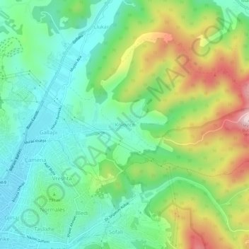
Name: Kolovicë topographic map, elevation, terrain.
Average elevation: 2,392 ft
Minimum elevation: 1,955 ft
Maximum elevation: 3,255 ft
Make a donation
Gear up for your next adventure:
As an Amazon Associate, this site earns from qualifying purchases at no extra cost to you.
Other topographic maps
Click on a map to view its topography, its elevation and its terrain.
Pristina
By the early Iron Age, the distinctly Dardanian local variant of the Illyrian Glasinac-Mati culture appears in Kosovo with a particular spread in hilltop settlements. In the area of Pristina, a hilltop settlement appears since the 8th century BCE at an elevation of 685 metres near the village Teneshdoll,…
Average elevation: 2,133 ft
Make a donation
Gear up for your next adventure:
As an Amazon Associate, this site earns from qualifying purchases at no extra cost to you.
Pristina
By the early Iron Age, the distinctly Dardanian local variant of the Illyrian Glasinac-Mati culture appears in Kosovo with a particular spread in hilltop settlements. In the area of Pristina, a hilltop settlement appears since the 8th century BCE at an elevation of 685 metres near the village Teneshdoll,…
Average elevation: 2,123 ft
Make a donation
Gear up for your next adventure:
As an Amazon Associate, this site earns from qualifying purchases at no extra cost to you.
Pristina
By the early Iron Age, the distinctly Dardanian local variant of the Illyrian Glasinac-Mati culture appears in Kosovo with a particular spread in hilltop settlements. In the area of Pristina, a hilltop settlement appears since the 8th century BCE at an elevation of 685 metres near the village Teneshdoll,…
Average elevation: 2,123 ft
Make a donation
Gear up for your next adventure:
As an Amazon Associate, this site earns from qualifying purchases at no extra cost to you.
Make a donation
Gear up for your next adventure:
As an Amazon Associate, this site earns from qualifying purchases at no extra cost to you.
Pristina
By the early Iron Age, the distinctly Dardanian local variant of the Illyrian Glasinac-Mati culture appears in Kosovo with a particular spread in hilltop settlements. In the area of Pristina, a hilltop settlement appears since the 8th century BCE at an elevation of 685 metres near the village Teneshdoll,…
Average elevation: 2,133 ft
Pristina
By the early Iron Age, the distinctly Dardanian local variant of the Illyrian Glasinac-Mati culture appears in Kosovo with a particular spread in hilltop settlements. In the area of Pristina, a hilltop settlement appears since the 8th century BCE at an elevation of 685 metres near the village Teneshdoll,…
Average elevation: 2,123 ft
Make a donation
Gear up for your next adventure:
As an Amazon Associate, this site earns from qualifying purchases at no extra cost to you.
Make a donation
Gear up for your next adventure:
As an Amazon Associate, this site earns from qualifying purchases at no extra cost to you.
Fushë Kosovë
Kosovo Polje is a municipality that lies in the center of the Kosovo Plain, with an area of 84 km2 (32 sq mi) and an altitude of 540 m (1,772 ft) above sea level. The city is situated between Pristina in the east, Obiliq in the north, Gračanica in the south and Drenas in the west. It consists of 16…
Average elevation: 1,808 ft
Make a donation
Gear up for your next adventure:
As an Amazon Associate, this site earns from qualifying purchases at no extra cost to you.
Make a donation
Gear up for your next adventure:
As an Amazon Associate, this site earns from qualifying purchases at no extra cost to you.
Make a donation
Gear up for your next adventure:
As an Amazon Associate, this site earns from qualifying purchases at no extra cost to you.
Make a donation
Gear up for your next adventure:
As an Amazon Associate, this site earns from qualifying purchases at no extra cost to you.
Make a donation
Gear up for your next adventure:
As an Amazon Associate, this site earns from qualifying purchases at no extra cost to you.
Pristina
By the early Iron Age, the distinctly Dardanian local variant of the Illyrian Glasinac-Mati culture appears in Kosovo with a particular spread in hilltop settlements. In the area of Pristina, a hilltop settlement appears since the 8th century BCE at an elevation of 685 metres near the village Teneshdoll,…
Average elevation: 2,133 ft
Pristina
By the early Iron Age, the distinctly Dardanian local variant of the Illyrian Glasinac-Mati culture appears in Kosovo with a particular spread in hilltop settlements. In the area of Pristina, a hilltop settlement appears since the 8th century BCE at an elevation of 685 metres near the village Teneshdoll,…
Average elevation: 2,123 ft
Make a donation
Gear up for your next adventure:
As an Amazon Associate, this site earns from qualifying purchases at no extra cost to you.
Pristina
By the early Iron Age, the distinctly Dardanian local variant of the Illyrian Glasinac-Mati culture appears in Kosovo with a particular spread in hilltop settlements. In the area of Pristina, a hilltop settlement appears since the 8th century BCE at an altitude of 685m near the village Teneshdoll, ~16 km to…
Average elevation: 2,133 ft
Pristina
By the early Iron Age, the distinctly Dardanian local variant of the Illyrian Glasinac-Mati culture appears in Kosovo with a particular spread in hilltop settlements. In the area of Pristina, a hilltop settlement appears since the 8th century BCE at an elevation of 685 metres near the village Teneshdoll,…
Average elevation: 2,123 ft
Make a donation
Gear up for your next adventure:
As an Amazon Associate, this site earns from qualifying purchases at no extra cost to you.