
Kingman topographic map
Click on the map to display elevation.
Kingman
Lt. Edward Fitzgerald Beale, a U.S. Navy officer in the service of the Army Corps of Topographical Engineers, was ordered by the U.S. War Department to build a federal wagon road across the 35th parallel. His secondary orders were to test the feasibility of the use of camels as pack animals in the Southwestern desert. Beale traveled through the present-day Kingman in 1857 surveying the road and in 1859 to build the road. Beale's Wagon Road became part of U.S. Route 66 and later Interstate 40. Remnants of the wagon road can still be seen in White Cliffs Canyon in Kingman.
About this map
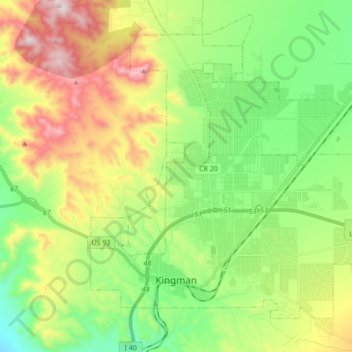
Name: Kingman topographic map, elevation, terrain.
Location: Kingman, Mohave County, Arizona, United States (35.17405 -114.09481 35.28733 -113.92299)
Average elevation: 3,711 ft
Minimum elevation: 2,713 ft
Maximum elevation: 5,407 ft
Mohave County trails, hiking, mountain biking, running and outdoor activities
Other topographic maps
Click on a map to view its topography, its elevation and its terrain.
Kingman
United States > Arizona > Mohave County > Kingman
Lt. Edward Fitzgerald Beale, a U.S. Navy officer in the service of the U.S. Army Corps of Topographical Engineers, was ordered by the U.S. War Department to build a federal wagon road across the 35th Parallel. His secondary orders were to test the feasibility of the use of camels as pack animals in the…
Average elevation: 3,711 ft
Kingman
United States > Arizona > Mohave County > Kingman
Lt. Edward Fitzgerald Beale, a U.S. Navy officer in the service of the Army Corps of Topographical Engineers, was ordered by the U.S. War Department to build a federal wagon road across the 35th parallel. His secondary orders were to test the feasibility of the use of camels as pack animals in the Southwestern…
Average elevation: 3,661 ft
Bullhead City
United States > Arizona > Mohave County > Bullhead City > Bullhead City
Average elevation: 804 ft
Littlefield
United States > Arizona > Mohave County > Beaver Dam > Littlefield
Average elevation: 1,929 ft
Fort Mojave Indian Tribe
United States > Arizona > Mohave County > Mohave Valley
Average elevation: 1,188 ft