
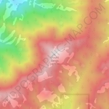
Mount Bangs topographic map
Click on the map to display elevation.
About this map
Name: Mount Bangs topographic map, elevation, terrain.
Location: Mount Bangs, Mohave County, Arizona, United States (36.79243 -113.85501 36.79253 -113.85491)
Average elevation: 6,722 ft
Minimum elevation: 4,731 ft
Maximum elevation: 7,920 ft
Mohave County trails, hiking, mountain biking, running and outdoor activities
Other topographic maps
Click on a map to view its topography, its elevation and its terrain.
Kingman
United States > Arizona > Mohave County > Kingman
Lt. Edward Fitzgerald Beale, a U.S. Navy officer in the service of the U.S. Army Corps of Topographical Engineers, was ordered by the U.S. War Department to build a federal wagon road across the 35th Parallel. His secondary orders were to test the feasibility of the use of camels as pack animals in the…
Average elevation: 3,711 ft
Kingman
United States > Arizona > Mohave County
Lt. Edward Fitzgerald Beale, a U.S. Navy officer in the service of the Army Corps of Topographical Engineers, was ordered by the U.S. War Department to build a federal wagon road across the 35th parallel. His secondary orders were to test the feasibility of the use of camels as pack animals in the Southwestern…
Average elevation: 3,711 ft
Fort Mojave Indian Tribe
United States > Arizona > Mohave County > Mohave Valley
Average elevation: 1,188 ft