
Make a donation
Gear up for your next adventure:
As an Amazon Associate, this site earns from qualifying purchases at no extra cost to you.
Bordeaux Hills topographic map
Click on the map to display elevation.
Make a donation
Gear up for your next adventure:
As an Amazon Associate, this site earns from qualifying purchases at no extra cost to you.
About this map
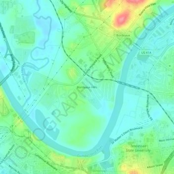
Name: Bordeaux Hills topographic map, elevation, terrain.
Average elevation: 449 ft
Minimum elevation: 381 ft
Maximum elevation: 653 ft
Davidson County trails, hiking, mountain biking, running and outdoor activities
Make a donation
Gear up for your next adventure:
As an Amazon Associate, this site earns from qualifying purchases at no extra cost to you.
Other topographic maps
Click on a map to view its topography, its elevation and its terrain.
Edwin Warner Park
United States > Tennessee > Davidson County > Nashville > Devonshire Manor
Average elevation: 650 ft
Make a donation
Gear up for your next adventure:
As an Amazon Associate, this site earns from qualifying purchases at no extra cost to you.
Harpeth River Greenway
United States > Tennessee > Davidson County > Nashville > Harpeth River Estates
Average elevation: 597 ft
J. Percy Priest Lake
United States > Tennessee > Davidson County > Nashville
Average elevation: 554 ft
Ellington Agricultural Center
United States > Tennessee > Davidson County > Nashville
Average elevation: 584 ft
Make a donation
Gear up for your next adventure:
As an Amazon Associate, this site earns from qualifying purchases at no extra cost to you.
Tennessee State Capitol
United States > Tennessee > Davidson County > Nashville
Average elevation: 456 ft