
Arlington topographic map
Click on the map to display elevation.
Arlington
The city lies on a glacial terrace formed during the Pleistocene epoch by the recession of the Cordilleran Ice Sheet. Arlington covers a series of hills that sit at an elevation of 100 to 200 feet (30 to 61 m) above sea level. Downtown Arlington is situated on a bluff above the confluence of the Stillaguamish River and its North and South Forks. Most of Arlington sits in the watersheds of the Stillaguamish River, Portage Creek, and Quilceda Creek. From various points in Arlington, the Olympic Mountains, Mount Pilchuck, and Mount Rainier are visible on the horizon.
About this map
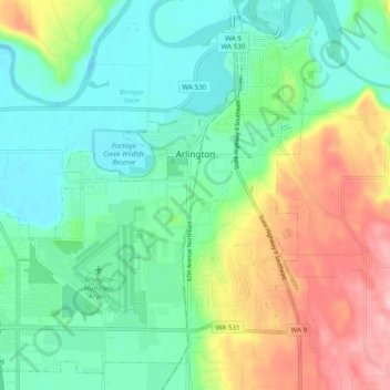
Name: Arlington topographic map, elevation, terrain.
Average elevation: 197 ft
Minimum elevation: 20 ft
Maximum elevation: 564 ft
Snohomish County trails, hiking, mountain biking, running and outdoor activities
Other topographic maps
Click on a map to view its topography, its elevation and its terrain.
Northwest Snohomish
United States > Washington > Snohomish County > Snohomish
Average elevation: 171 ft
Glacier Peak
United States > Washington > Snohomish County
Despite its elevation of 10,541 feet (3,213 m), Glacier Peak is a small stratovolcano. Its relatively high summit is a consequence of its location atop a high ridge, but its volcanic portion extends only 1,600–3,200 feet (500–1,000 m) above the underlying ridge. Another Cascade Arc volcano with similar…
Average elevation: 8,714 ft
Mill Creek
United States > Washington > Snohomish County > Mill Creek > Mill Creek
Average elevation: 423 ft
Whitehorse Mountain
United States > Washington > Snohomish County
Whitehorse Mountain is a peak near the western edge of the North Cascades in Washington state. It is located just southwest of the Sauk River Valley town of Darrington, near the northern boundary of Boulder River Wilderness in Mount Baker-Snoqualmie National Forest. While not of particularly high absolute…
Average elevation: 4,692 ft
Lynnwood
United States > Washington > Snohomish County > Lynnwood > Lynnwood
Average elevation: 367 ft
Bridal Veil Falls-Lower East Cascade
United States > Washington > Snohomish County
Average elevation: 2,037 ft