
Big Four Ice Caves topographic map
Interactive map
Click on the map to display elevation.
About this map
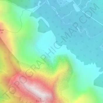
Name: Big Four Ice Caves topographic map, elevation, terrain.
Average elevation: 2,989 ft
Minimum elevation: 1,673 ft
Maximum elevation: 6,138 ft
Snohomish County trails, hiking, mountain biking, running and outdoor activities
Other topographic maps
Click on a map to view its topography, its elevation and its terrain.
Seattle Hill-Silver Firs
United States > Washington > Snohomish County > Seattle Hill-Silver Firs
Average elevation: 305 ft
Stanwood
United States > Washington > Snohomish County > Stanwood
The city is located at the mouth of the Stillaguamish River, where it flows into Port Susan, an arm of the Puget Sound, and Skagit Bay, the mouth of the Skagit River. To the west is Davis Slough, which separates Stanwood from Camano Island, and forms the border between Snohomish and Island counties. Elevations…
Average elevation: 66 ft