
Make a donation
Gear up for your next adventure:
As an Amazon Associate, this site earns from qualifying purchases at no extra cost to you.
São Gabriel topographic map
Click on the map to display elevation.
Make a donation
Gear up for your next adventure:
As an Amazon Associate, this site earns from qualifying purchases at no extra cost to you.
São Gabriel
O clima é do tipo subtropical úmido predominante em toda região do estado de baixa altitude. As estações são bem definidas com verões quentes e úmidos causando uma sensação térmica desagradável durante boa parte da estação. O outono é marcado pela chegada de um frio moderado que se torna rigoroso algumas semanas antes da entrada oficial. O inverno registra temperaturas baixas com geadas frequentes, acompanhado por um vento forte chamado de minuano, que é de origem polar e também pelo vento pampeiro, um vento frio e violento, que vem do pampa argentino e que aumenta a sensação de frio consideravelmente. A primavera possui finalmente um clima equilibrado e agradável.
Make a donation
Gear up for your next adventure:
As an Amazon Associate, this site earns from qualifying purchases at no extra cost to you.
About this map
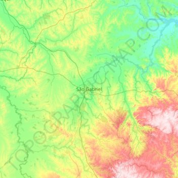
Name: São Gabriel topographic map, elevation, terrain.
Average elevation: 512 ft
Minimum elevation: 161 ft
Maximum elevation: 1,512 ft
Make a donation
Gear up for your next adventure:
As an Amazon Associate, this site earns from qualifying purchases at no extra cost to you.
Other topographic maps
Click on a map to view its topography, its elevation and its terrain.
Porto Alegre
Brasil > Rio Grande do Sul > Região Metropolitana de Porto Alegre > Porto Alegre
Geologicamente a estrutura do terreno porto-alegrense é muito antiga. A cidade está localizada dentro dos limites da Bacia do Paraná, uma extensa bacia sedimentar que se estende para o norte até o centro do Brasil, cujos primeiros sedimentos foram depositados no Paleozoico, com vários acúmulos…
Average elevation: 89 ft
Make a donation
Gear up for your next adventure:
As an Amazon Associate, this site earns from qualifying purchases at no extra cost to you.
Make a donation
Gear up for your next adventure:
As an Amazon Associate, this site earns from qualifying purchases at no extra cost to you.
Morro São João
Brasil > Rio Grande do Sul > Região Metropolitana de Porto Alegre > Montenegro
Average elevation: 108 ft
Make a donation
Gear up for your next adventure:
As an Amazon Associate, this site earns from qualifying purchases at no extra cost to you.
Novo Hamburgo
Brasil > Rio Grande do Sul > Região Metropolitana de Porto Alegre > Novo Hamburgo
Average elevation: 322 ft
Make a donation
Gear up for your next adventure:
As an Amazon Associate, this site earns from qualifying purchases at no extra cost to you.
Concórdia
Brasil > Rio Grande do Sul > Região Metropolitana de Porto Alegre > Parobé
Average elevation: 456 ft
Três Irmãos
Brasil > Rio Grande do Sul > Região Metropolitana de Porto Alegre > Taquara
Average elevation: 1,319 ft
Make a donation
Gear up for your next adventure:
As an Amazon Associate, this site earns from qualifying purchases at no extra cost to you.
Santa Cruz do Pinhal
Brasil > Rio Grande do Sul > Região Metropolitana de Porto Alegre > Taquara
Average elevation: 728 ft
Make a donation
Gear up for your next adventure:
As an Amazon Associate, this site earns from qualifying purchases at no extra cost to you.
Monjolo
Brasil > Rio Grande do Sul > Região Metropolitana de Porto Alegre > Santo Antônio da Patrulha
Average elevation: 171 ft
Make a donation
Gear up for your next adventure:
As an Amazon Associate, this site earns from qualifying purchases at no extra cost to you.
Praça da Bíblia
Brasil > Rio Grande do Sul > Região Metropolitana de Porto Alegre > Cachoeirinha
Average elevation: 144 ft
Morro do Farol
Brasil > Rio Grande do Sul > Aglomeração Urbana do Litoral Norte > Torres
Average elevation: 13 ft
Paquete
Brasil > Rio Grande do Sul > Região Metropolitana de Porto Alegre > Capela de Santana
Average elevation: 108 ft
Make a donation
Gear up for your next adventure:
As an Amazon Associate, this site earns from qualifying purchases at no extra cost to you.
Rio dos Sinos
Brasil > Rio Grande do Sul > Região Metropolitana de Porto Alegre > Sapiranga
Average elevation: 92 ft
Make a donation
Gear up for your next adventure:
As an Amazon Associate, this site earns from qualifying purchases at no extra cost to you.
Mirante do Morro da Borússia
Brasil > Rio Grande do Sul > Aglomeração Urbana do Litoral Norte > Osório
Average elevation: 646 ft
Praça das Carretas
Brasil > Rio Grande do Sul > Aglomeração Urbana do Litoral Norte > Osório
Average elevation: 72 ft
Make a donation
Gear up for your next adventure:
As an Amazon Associate, this site earns from qualifying purchases at no extra cost to you.
Parque Alim Pedro
Brasil > Rio Grande do Sul > Região Metropolitana de Porto Alegre > Porto Alegre
Average elevation: 92 ft
Morro Grande
Brasil > Rio Grande do Sul > Região Metropolitana de Porto Alegre > Viamão
Average elevation: 128 ft
Make a donation
Gear up for your next adventure:
As an Amazon Associate, this site earns from qualifying purchases at no extra cost to you.
Make a donation
Gear up for your next adventure:
As an Amazon Associate, this site earns from qualifying purchases at no extra cost to you.
Make a donation
Gear up for your next adventure:
As an Amazon Associate, this site earns from qualifying purchases at no extra cost to you.
Praça Doutor Jurandir Barcellos da Silva
Brasil > Rio Grande do Sul > Região Metropolitana de Porto Alegre > Porto Alegre
Average elevation: 187 ft
Make a donation
Gear up for your next adventure:
As an Amazon Associate, this site earns from qualifying purchases at no extra cost to you.
Praça Conde de Porto Alegre
Brasil > Rio Grande do Sul > Região Metropolitana de Porto Alegre > Porto Alegre
Em 1919 sua topografia foi reformulada, diminuindo-se a declividade do terreno. Na administração do prefeito Telmo Thompson Flores (1969-1975) o espaço sofreu nova reforma, para a construção do Viaduto Loureiro da Silva, restando apenas uma parcela de sua área primitiva.
Average elevation: 43 ft
Praça Isabel, a Católica
Brasil > Rio Grande do Sul > Região Metropolitana de Porto Alegre > Porto Alegre
Average elevation: 39 ft
Make a donation
Gear up for your next adventure:
As an Amazon Associate, this site earns from qualifying purchases at no extra cost to you.
Morro São Pedro
Brasil > Rio Grande do Sul > Região Metropolitana de Porto Alegre > Porto Alegre
Esta elevação granítica, com 289 metros de altitude máxima, abriga os maiores contínuos de vegetação nativa do município (cerca de 1000 hectares de florestas e 550 hectares de campos) que abrigam nascentes de água límpida de duas das principais bacias hidrográficas de Porto Alegre, as sub-bacias do…
Average elevation: 436 ft
Praça Antônio Cândido de Menezes
Brasil > Rio Grande do Sul > Região Metropolitana de Porto Alegre > Porto Alegre
Average elevation: 43 ft
Parque Getúlio Vargas
Brasil > Rio Grande do Sul > Região Metropolitana de Porto Alegre > Canoas
Average elevation: 72 ft
Make a donation
Gear up for your next adventure:
As an Amazon Associate, this site earns from qualifying purchases at no extra cost to you.
Praça Moinhos de Vento II
Brasil > Rio Grande do Sul > Região Metropolitana de Porto Alegre > Canoas
Average elevation: 95 ft
Balneário dos Prazeres
Brasil > Rio Grande do Sul > Aglomeração Urbana do Sul > Pelotas
Average elevation: 23 ft
Associação Rural de Pelotas
Brasil > Rio Grande do Sul > Aglomeração Urbana do Sul > Pelotas
Average elevation: 49 ft
Praça Marechal Deodoro
Brasil > Rio Grande do Sul > Região Metropolitana de Porto Alegre > Porto Alegre
Estabelecendo-se lentamente, a praça até 1840 não passava de uma elevação erodida, sem qualquer adorno. Nessa década foram então construídas as primeiras calçadas, e na segunda metade do século XIX, passada a agitação causada pela Revolução Farroupilha, quando a cidade foi sitiada por dez anos,…
Average elevation: 33 ft
Make a donation
Gear up for your next adventure:
As an Amazon Associate, this site earns from qualifying purchases at no extra cost to you.
Praça Domingos Rodrigues
Brasil > Rio Grande do Sul > Aglomeração Urbana do Sul > Pelotas
Average elevation: 16 ft
Barra Falsa
Brasil > Rio Grande do Sul > Aglomeração Urbana do Sul > Rio Grande
Average elevation: 10 ft
Praça Barão do Rio Branco
Brasil > Rio Grande do Sul > Região Metropolitana de Porto Alegre > Canoas
Average elevation: 33 ft
Make a donation
Gear up for your next adventure:
As an Amazon Associate, this site earns from qualifying purchases at no extra cost to you.
Quinta Secção da Barra
Brasil > Rio Grande do Sul > Aglomeração Urbana do Sul > São José do Norte
Average elevation: 3 ft
Morro Santana
Brasil > Rio Grande do Sul > Região Metropolitana de Porto Alegre > Porto Alegre
Average elevation: 545 ft
Morro Santana
Brasil > Rio Grande do Sul > Região Metropolitana de Porto Alegre > Eldorado do Sul
Average elevation: 545 ft
Make a donation
Gear up for your next adventure:
As an Amazon Associate, this site earns from qualifying purchases at no extra cost to you.
Praça Cristóvão Colombo
Brasil > Rio Grande do Sul > Região Metropolitana de Porto Alegre > Canoas
Average elevation: 30 ft
Balneário Atlântico
Brasil > Rio Grande do Sul > Aglomeração Urbana do Litoral Norte > Arroio do Sal
Average elevation: 16 ft
Fernando Ferrari
Brasil > Rio Grande do Sul > Aglomeração Urbana do Litoral Norte > Três Cachoeiras
Average elevation: 223 ft
Farol da Solidão
Brasil > Rio Grande do Sul > Mostardas > Praia do Farol da Solidão
Average elevation: 16 ft
Make a donation
Gear up for your next adventure:
As an Amazon Associate, this site earns from qualifying purchases at no extra cost to you.
Make a donation
Gear up for your next adventure:
As an Amazon Associate, this site earns from qualifying purchases at no extra cost to you.
Faxinal do Morro Alto
Brasil > Rio Grande do Sul > Aglomeração Urbana do Litoral Norte > Maquiné
Average elevation: 16 ft
Praia Nova Tramandai Sul
Brasil > Rio Grande do Sul > Aglomeração Urbana do Litoral Norte > Tramandaí
Average elevation: 13 ft
Make a donation
Gear up for your next adventure:
As an Amazon Associate, this site earns from qualifying purchases at no extra cost to you.
Ponta do Tigre
Brasil > Rio Grande do Sul > Região Metropolitana de Porto Alegre > Viamão
Average elevation: 56 ft
Make a donation
Gear up for your next adventure:
As an Amazon Associate, this site earns from qualifying purchases at no extra cost to you.
Arroio Araçá
Brasil > Rio Grande do Sul > Região Metropolitana de Porto Alegre > Canoas
Average elevation: 52 ft
Make a donation
Gear up for your next adventure:
As an Amazon Associate, this site earns from qualifying purchases at no extra cost to you.
Rio Rolante
Brasil > Rio Grande do Sul > Região Metropolitana de Porto Alegre > Rolante
Average elevation: 112 ft
Make a donation
Gear up for your next adventure:
As an Amazon Associate, this site earns from qualifying purchases at no extra cost to you.