
Make a donation
Gear up for your next adventure:
As an Amazon Associate, this site earns from qualifying purchases at no extra cost to you.
Ebsdorf topographic map
Click on the map to display elevation.
Make a donation
Gear up for your next adventure:
As an Amazon Associate, this site earns from qualifying purchases at no extra cost to you.
About this map
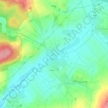
Name: Ebsdorf topographic map, elevation, terrain.
Average elevation: 745 ft
Minimum elevation: 630 ft
Maximum elevation: 1,001 ft
Make a donation
Gear up for your next adventure:
As an Amazon Associate, this site earns from qualifying purchases at no extra cost to you.
Other topographic maps
Click on a map to view its topography, its elevation and its terrain.
Neustadt (Hessen)
Deutschland > Hessen > Landkreis Marburg-Biedenkopf > Neustadt
Average elevation: 958 ft
Wallau (Lahn)
Deutschland > Hessen > Landkreis Marburg-Biedenkopf > Biedenkopf > Wallau (Lahn)
Average elevation: 1,217 ft
Make a donation
Gear up for your next adventure:
As an Amazon Associate, this site earns from qualifying purchases at no extra cost to you.
Rüchenbach
Deutschland > Hessen > Landkreis Marburg-Biedenkopf > Rüchenbach
Die Statistisch-topographisch-historische Beschreibung des Großherzogthums Hessen berichtet 1830 über Rüchenbach.
Average elevation: 919 ft
Bernberg
Deutschland > Hessen > Landkreis Marburg-Biedenkopf > Breidenbach
Average elevation: 1,358 ft
Make a donation
Gear up for your next adventure:
As an Amazon Associate, this site earns from qualifying purchases at no extra cost to you.
Hinterstein
Deutschland > Hessen > Landkreis Marburg-Biedenkopf > Breidenbach
Average elevation: 1,204 ft
Bracht-Siedlung
Deutschland > Hessen > Landkreis Marburg-Biedenkopf > Rauschenberg
Average elevation: 951 ft
Hartenrod
Deutschland > Hessen > Landkreis Marburg-Biedenkopf > Bad Endbach
Die Statistisch-topographisch-historische Beschreibung des Großherzogthums Hessen berichtet 1830 über Hartenrod.
Average elevation: 1,385 ft
Make a donation
Gear up for your next adventure:
As an Amazon Associate, this site earns from qualifying purchases at no extra cost to you.
Günterod
Deutschland > Hessen > Landkreis Marburg-Biedenkopf > Bad Endbach
Kreuzungspunkt alter Höhenwege mit Turmburg
Average elevation: 1,299 ft
Am Kleeberg
Deutschland > Hessen > Landkreis Marburg-Biedenkopf > Biedenkopf > Ludwigshütte
Average elevation: 1,178 ft
Make a donation
Gear up for your next adventure:
As an Amazon Associate, this site earns from qualifying purchases at no extra cost to you.
Dilschhausen
Deutschland > Hessen > Landkreis Marburg-Biedenkopf > Marburg > Dilschhausen
Average elevation: 988 ft
Niederwetter
Deutschland > Hessen > Landkreis Marburg-Biedenkopf > Wetter > Niederwetter
Average elevation: 771 ft
Make a donation
Gear up for your next adventure:
As an Amazon Associate, this site earns from qualifying purchases at no extra cost to you.
Mellnauer Kreuz
Deutschland > Hessen > Landkreis Marburg-Biedenkopf > Wetter > Mellnau
Average elevation: 1,129 ft
Hassenroth
Deutschland > Hessen > Landkreis Marburg-Biedenkopf > Biedenkopf
Average elevation: 1,608 ft
Make a donation
Gear up for your next adventure:
As an Amazon Associate, this site earns from qualifying purchases at no extra cost to you.