
Make a donation
Gear up for your next adventure:
As an Amazon Associate, this site earns from qualifying purchases at no extra cost to you.
Lake Tahoe topographic map
Click on the map to display elevation.
Make a donation
Gear up for your next adventure:
As an Amazon Associate, this site earns from qualifying purchases at no extra cost to you.
Lake Tahoe
Lake Tahoe is renowned for its dramatic topography, characterized by rugged mountain ranges and deep, crystal-clear waters. Nestled in the Sierra Nevada, the lake itself lies at an elevation of approximately 6,225 feet (1,897 meters) and spans about 22 miles (35 kilometers) in length and 12 miles (19 kilometers) in width. Its maximum depth reaches an impressive 1,645 feet (501 meters), making it the second-deepest lake in the United States. The surrounding terrain features steep hills and mountains, with elevations ranging up to 9,000 feet (2,743 meters) above sea level, contributing to a varied landscape of lush forests and rocky outcrops. The region experiences significant seasonal snow, with most precipitation falling between November and April, which influences both the ecology and recreational activities in the area.
Make a donation
Gear up for your next adventure:
As an Amazon Associate, this site earns from qualifying purchases at no extra cost to you.
About this map
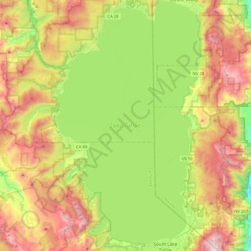
Name: Lake Tahoe topographic map, elevation, terrain.
Location: Lake Tahoe, Placer County, California, United States (38.92817 -120.16394 39.24901 -119.92606)
Average elevation: 6,814 ft
Minimum elevation: 4,777 ft
Maximum elevation: 9,728 ft
Placer County trails, hiking, mountain biking, running and outdoor activities
Make a donation
Gear up for your next adventure:
As an Amazon Associate, this site earns from qualifying purchases at no extra cost to you.
Other topographic maps
Click on a map to view its topography, its elevation and its terrain.
Make a donation
Gear up for your next adventure:
As an Amazon Associate, this site earns from qualifying purchases at no extra cost to you.
Make a donation
Gear up for your next adventure:
As an Amazon Associate, this site earns from qualifying purchases at no extra cost to you.
Make a donation
Gear up for your next adventure:
As an Amazon Associate, this site earns from qualifying purchases at no extra cost to you.
Make a donation
Gear up for your next adventure:
As an Amazon Associate, this site earns from qualifying purchases at no extra cost to you.
Carnelian Bay
United States > California > Placer County
For statistical purposes, the United States Census Bureau has defined Carnelian Bay as a census-designated place (CDP). The census definition of the area may not precisely correspond to local understanding of the area with the same name. The population was 524 at the 2010 census. The elevation is 6,325 feet…
Average elevation: 6,486 ft
Make a donation
Gear up for your next adventure:
As an Amazon Associate, this site earns from qualifying purchases at no extra cost to you.
Make a donation
Gear up for your next adventure:
As an Amazon Associate, this site earns from qualifying purchases at no extra cost to you.
Make a donation
Gear up for your next adventure:
As an Amazon Associate, this site earns from qualifying purchases at no extra cost to you.
Make a donation
Gear up for your next adventure:
As an Amazon Associate, this site earns from qualifying purchases at no extra cost to you.
Make a donation
Gear up for your next adventure:
As an Amazon Associate, this site earns from qualifying purchases at no extra cost to you.
Blue Canyon
United States > California > Placer County
Blue Canyon (also, Blue Cañon) is an unincorporated community in Placer County, California. Blue Canyon is located 4 miles (6.4 km) southwest of Emigrant Gap. It lies at an elevation of 4695 feet (1431 m).
Average elevation: 4,764 ft
Make a donation
Gear up for your next adventure:
As an Amazon Associate, this site earns from qualifying purchases at no extra cost to you.